

Points where the ley energy paths intersect are said to be prone to anomalies such as earth lights, poltergeist phenomena and reported sightings of UFOs. One theory even suggests that the paths are navigational aids to extraterrestrial spacecraft.
Alignments and patterns of powerful, invisible earth energy said to connect various sacred sites, such as churches, temples, stone circles, megaliths, holy wells, burial sites, and other locations of spiritual or magical importance.
The existence of leys is controversial. If they do exist, their true age and purpose remain a mystery. Controversy over them has existed since 1925, when Alfred Watkins, an English beer salesman and amateur antiquarian, published his research and theory in his book, ‘The Old Straight Track‘. Watkins suggested that all holy sites and places of antiquity were connected by a pattern of lines he called ‘leys’. Mounds, barrows, tumuli, stones, stone circles, crosses, churches built on pagan sites, legendary trees, castles, mottes and baileys, moats, hillforts, earthworks and holy wells were all thought to stand in alignment. Using the Ordnance Survey, Watkins claimed that the leys were the ‘old straight tracks’, which crossed the landscape of prehistoric Britain and represented all types of early human activities.

After Watkins’s theory was published, public fascination with leys remained high until the 1940s, when it began to decline. Interest revived in the 1960s and 1970s, as part of the New Age movement. While Britain has been the chief site of investigation, there also is interest in France, the United States, Peru and Bolivia. Many archaeologists and other scientists dispute the existence of leys and say the theory originated by Watkins was contrived because Watkins aligned secular and sacred sites from different periods of history. Even ley enthusiasts are divided into differing camps. Some hold that the prehistoric alignments can be statistically validated. Others agree but say that alignments continued in historical periods. Still others contend that leys mark paths of some sort of earth energy that can be detected by dowsing, and perhaps was sensed by early humans. The energy is compared to the flow of ch’i, the universal life force identified in ancient Chinese philosophy.
Points where the ley energy paths intersect are said to be prone to anomalies such as earth lights and poltergeist phenomena and reported sightings of UFOs (one theory suggests that the paths are navigational aids to extraterrestrial spacecraft). These energy leys, however, do not necessarily coincide with physical alignments of sites. Despite the controversy ley researchers hope at least to come to a better understanding of ancient sacred sites, and of the people who built them.
No book on the subject ofmegalithic monuments would be complete without a mention of ley lines. Leys are straight tracks or paths which connect up ancient and sacred sites in straight lines which cover the countryside. They were created in the distant prehistoric past, by peaceful ancient tribes, possibly the survivors of a lost civilization, who needed straight paths through the forests and across the hills. The other function of ley lines was to concentrate and redirect potent earth energies to enable the people to live in fulfilment and plenty.
These lines had been totally forgotten, and were only rediscovered in the 20th century. After it had been accepted that megalithic sites could form short alignments, the idea was extended dramatically by a retired amateur antiquarian called Alfred Watkins, in the 1920s.
In two publications, ‘Early British Trackways’ and ‘The Old Straight Track’, he made the case for a pattern of interconnected straight lines which criss-crossed England. These were derived ultimately from the Stone age, when people travelled the country by following tracks straight from one landmark to the next visible one. The lines are also related to the seasonal positions of the sun, especially the solstices, and the moon. Prehistoric monuments such as standing stones, circles and chambered cairns and even settlements were constructed on these lines and at the junctions of lines. During following periods, the pattern was maintained, so that a ley line could include churches, sacred trees, wells, beacon hills, forts, crosses, fords and bridges, as well as Stone Age and Bronze Age sites.
Watkins’ ideas made some impact, and clubs were formed to advance ley-line discovery. Though interest faded after Watkins’ death, there was a revival in the 1960s, when many new ley lines were identified, and there is still some work going on even today, mainly by the sort of person who is also interested in crop-circles.
Anyone can discover new leys by utilising a map, a pencil and a long ruler, and joining up the sites marked. You may wish to try this yourself, if you have an OS map handy. Any kind of site from any period is acceptable. When a promising line is found in your area, then next step is to go out and check it on the ground. Often, when exploring and following such lines, it will be found that natural features of the countryside are utilized also. Such things as notches on the skyline, or copses of trees can be used to keep your path straight. Often, traces of the paths or tracks themselves will become visible, although you should be careful, as these may simply have been trampled flat by previous ley explorers.
A map of the main Scottish leys has been published. One of the most impressive leys is the one which leaves Stirling, becoming the `Old Straight Track’ the monks took to Iona. Passing over the summit of Ben Lomondand directly across Loch Lomond, this line carries on over the Cobbler and so west across Loch Fyne, Loch Awe and the Firth of Lorne to arrive at its destination. Reluctantly, we conclude that only a crow or a holy man with aparaglider could travel that way.
It was always obvious to most people even in the 1920s that the creation of leys in the minds of its believers relied on two things – the existence of cheap detailed maps, and the density and length of human settlement over the last 4000 years. Each map contains dozens of old sites, some of which a believer can always connect with a pencil. Not even credible in their most innocent form as prehistoric trackways taking the shortest distance between two points over the smooth rolling downs of southern England, ley lines become ludicrous when run across the lumpier terrain of Scotland.
Following a ley line does not bring anyone close to their prehistoric ancestors, but carries them much further away. Leys, as a modern wish fulfilment, are one of the best examples of the truism that every generation gets the picture of the prehistoric past that it wants. In this case it is a peaceful golden age of lost knowledge.
There were no secret powers in past times which modern humanity has forgotten how to tap. There were only men and women who among other things, wanted to understand something of their universe, and to record what they knew in a permanent way. That achievement is so striking, for small numbers of people with only a stone age or very limited metal-used technology, that we can only admire and respect it. But ley lines belong in Middle Earth with the other great fictions of the 20th century.
The mystery is, why do so many people still believe in them?
LEY LINES AND VORTICES OF THE AMERICAN WEST
INTRODUCTION: DEFINITION OF LEY LINES AND VORTICES
Vortices appear to be points of power or energy on the Earth, and ley lines are the relationships between those points. An analogy might be that the vortices are accupressure points. and the ley lines between them are meridians on the skin of the body of Mother Earth.
However, reality is likely not so simple. My theory is that there is a template for this physical reality in a world existing concomitant with this one, and that template is geometric, or mathematical in organization. Matter is here, then not here, moving back and forth between implicate and explicate reality, as described in the theories of David Bohm, a contemporary and colleague of Einstein. This template for matter as we experience it in this explicate reality (the physical world) is in implicate reality, as also described in the "morphogenetic fields" of Rupert Sheldrake, a biologist at Cambridge in the 1960’s.2Joel Goldsmith, a metaphysical healer, often alludes to the same kind of system in his books, Jane Roberts mentions It in the Seth books, and Swedenborg Wrote of the correspondence between this world and that of the spiritual in Heaven and Hell, paragraph 90.
If this is what is, then it’s possible that the template for our Earth ‘in that unseen reality is crystalline ‘in organization. Furthermore, that crystalline matrix seems to be similar to a geodesic dome–a series of triangular shapes fit together to form the skin of a sphere. The joining on the surface of the Earth at the apexes of these triangles are points of energy focus, the vortices of the Earth. Some of the principal lines of force Join -mg these vortices, called "ley lines, " form triangular shapes between vortices.
At these foci of energy Earth, as it forms ‘in explicate reality (our world as we sense it), reveals the presence of these foci, or vortices, by -nations of geologic significance: These formations are volcanoes, high mountains, hot springs, mineral deposits, ends of sand spits near the ocean, sea mounts, forks of rivers, river mouths, large falls, deep gorges, rock outcroppings, and possibly others. Some dams are located on vortices, and often mineral deposits, especially gold, denote a vortex. There is a whole swirl of vortices around and near the Golden Gate Bridge, and these might be the coming together of several faults–many ley lines follow the great faults and waterways on the surface of our earth.
This system of vortices and ley lines is not a new idea. Sacred temples of the ancient world around the Mediterranean are located at powerful vortices, and drawing lines between them will bring out patterns of triangles. The Indians in the American Southwest as well as those in Peru and other parts of South America located their cities and the roads between them on vortices and ley lines, which look Like so many spokes and hubs. The Chinese practice the ancient science of geomancy. "The Olde Straite Pathes" of England,3 the location of Stonehenge and it’s relationship to the Great Pyramid, Glastonbury and the myth of Avalon correlate to vortices. I’m sure there are many more examples throughout the world.
Edgar Cayce spoke of gigantic earthquakes in Southern California after Mount Etna in Italy and Mount Pelee on the Island of Martinique exploded. Maybe they’re all on the same ley line. I believe that these major lines "crack" the Earth in a regular, mathematical pattern. a function of pi. A geological graduate student in Montana proposed such a theory in the late sixties. I suspect that earthquakes that occur close to each other in time often represent earth movement along the same ley line. Many times I have found this to be so. For instance, Sheep Peak, near Las Vegas, and Winnemucca also, is connected to Mt. Rainier and the Point occupied by Port Townsend in the Puget Sound. Earthquakes have happened on the same day along this ley line.
The Chinese have practiced geomancy for thousands of years, and the cathedrals of Europe are located on powerful vortices. I suspect that many of the old Spanish missions are located on sacred ground here in our American West. To me, some of the cities on the West Coast seem to be located in really the wrong spots: Seattle, Portland, San Francisco and Los Angeles are situated in areas of confused jumbles of ley lines crossing every which way. Living might be more pleasant and secure if we would take the time to find a harmonious spot for the location of buildings and towns. If your house is crossed ley a ley line, and you don’t like it, consult .with an old-time dowser as to ways of putting rebar in the ground connected by copper wire to pass the force around rather than through. your property.
Furthermore, I believe that the discomfort of "jet lag" felt after a long trip is our bodies complaining about crossing so many electromagnetic lines. This strips off our outer bodies — astral, etheric, and mental — which are susceptible to electronic forces. I usually feel terrible after driving the 1-5 freeway from Southern Oregon to Southern California because it crosses, rather than follows, some powerful lines between major vortices. After such a trip, I feel that I have to get myself "back together" again. If our highways, railroad tracks and airways were laid out Following ley lines rather than crossing them, we would move harmonious- with the earth, and our bodies would not suffer as they do now.
From an imaginary viewpoint out in space. large vortices appear to be the hubs of wheels, and the spokes emanating from them are ley lines. Some of these "spokes" are more powerful than others, just as there seems to be different degrees of strength to the vortices. These spokes are like gears. in that the spokes are fixed, but energy whirls about. to and from the vortices, moving from spoke to spoke in whirls o different and changing frequencies. Until we devise instruments to monitor and measure these lines of force, this idea will be only conjecture.
As viewed from space, some of these ley lines will cross each other, three or more of them, at exactly the same spot. These points of crossings are often in uninhabited places, wastelands or mountain areas so avoided that there is often no mountain or place name nearby to name them. These points of crossings I call Derived Vortices. Some of these Derived vortices are obviously quite powerful, because I found them by noticing the intersection of principal ley, lines (lines from known important vortices). These derived vortices and their relationships, or ley lines, between each other also meet three or more at exact points, forming further derivations. Often, near derived vortices, the aeronautical charts note areas of magnetic disturbance.
Except for the lines that end at Santa Barbara, the Oregon Vortex and the trench off the coast of Southern Oregon, almost all of these principal lines continue on to other countries and continents. I have limited myself to the American West because that is the area that I know. In years past. I have flown over (in a light plane), driven by, and hiked or camped on or near many of these sacred places.
[Footnotes:
2
SORRY… check back for updates!
3 For an excellent exposition on vortices and ley lines, read View Over Atlantis by John Michell (New York: Ballantine, 1973).]

![]() Ley-lines - (‘Ley’,’lea’ – ‘A clearing’)
Ley-lines - (‘Ley’,’lea’ – ‘A clearing’)
(‘Heilige Linien’ to the Germans ‘Fairy paths’ to the Irish, ‘Dragon Lines’ to the Chinese, ‘Spirit Lines’ to Peruvians and ‘Dream paths’ (Turingas) to the Australian Aborigines – and so on around the world).
Featured articles:
Most cultures have traditions and words to describe the straight, often geometric alignments that ran across ancient landscapes, connecting both natural and sacred prehistoric structures together. Usually the names given to represent these invisible lines are translated to an equivalent of ‘spirit‘, ‘dream‘, or ‘energy‘ paths. However, apart from the physical presence of the sites themselves, proving the presence of a ‘connection’ between them is something that researchers have found notoriously elusive.
Amongst the widely differing (and often simplistic) theories that attempt to explain why ley-lines and landscape alignments first appeared, the following theories probably say as much about us now as at any time in the past, yet we are bound to acknowledge and respect the following writers opinions and conclusions as ‘they’, the following few, are the giants upon whose shoulders this field of study current sits:
What is a Ley-line?
Even though the term ‘Ley-line was originally conceived by Alfred ‘Watkins, by 1929, he had discarded the use of the name ‘ley’ and referred to his alignments only as ‘old straight tracks’ or ‘archaic tracks’
"It is quite useless looking for existing fragments, however old, of roads which may remain from the first track, although, as we shall see, some bits may form useful indications of its site. The changes from early days have been so many in the matter of roads. We must therefore clear our minds, not only of what we think of roads, even Roman ones, but of our surmises, and begin again." - Alfred Watkins (4)
-
The current definition of a Ley-line according to http//:Wilkipedia.en.org/ is as follows:
‘Ley lines are hypothetical alignments of a number of places of geographical interest, such as ancient monuments and megaliths. Their existence was suggested in 1921 by the amateur archaeologist Alfred Watkins, whose book ‘The Old Straight Track’ brought the alignments to the attention of the wider public’.
This explanation by no means completes the modern definition of a ley-line, as we cannot say for example that all alignments of stones are ley-lines, however old they are. Nor does it follow that all ancient sites were aligned deliberately, even those that appear to have been.
Alfred Watkins, the modern founding father on the subject, created the first basic set of guidelines in order to describe ley-lines according to his perception. As we have learned more about ley lines, so we have had to adapt these original guidelines in order to explain our findings, whilst keeping to the context with Watkins’ original ideas.
Ley-Markers:
The following natural and manmade features were suggested by Watkins to be reliable ley-markers:
Mounds, Long-barrows, Cairns, Cursus, Dolmens, Standing stones, mark-stones, Stone circles, Henges, Water-markers (moats, ponds, springs, fords, wells), Castle, Beacon-hills, Churches, Cross-roads, Notches in hills, Camps (Hill-forts),
Any true Watkinsian ley requires it to have a start (or finish) point in the shape of a hill. (4)
From map and fieldwork, Deveraux concluded that all Henges are likely to indicate the presence of a Ley. (2)
We can therefore begin to gauge the strength of a ley-line according to its length, accuracy of deviation, number of ley-markers and their individual significance. We can also separate ley lines into basic categories such as astronomical, funerary, geometric etc, as the following examples illustrate:
What was the original purpose(s) of ley-lines.
There are several developed theories on this subject, many of which offer valid potential; something which in itself illustrates the complexity of unravelling the myriad of alignments from several millennia of activity.
We are still learning and have much more to learn in this field of study. It is likely that ley-lines are a product of different parts from several of the following theories, being created at different times, for different purposes. The following examples are the current contenders for explaining how such a dedication to straight-lines has led mankind its present position. It is important to recognise the distinction between ley-lines from geometric alignments.
Spirit ways and Death roads – (Funerary paths):
 Although there is little direct evidence for ‘religious’ worship in the modern sense of the word at megalithic sites, there is certainly evidence that funerary rites were involved at several important locations (some of which may be classed a secondary use). The burial of valuable goods alongside funerary remains, placing of remains inside stone chambers underground, and alignment of funerary structures or their inhabitants with the rising sun, all attest to the fact that funerary ley-markers were not placed according to purely ‘scientific’ criteria, although they may also have been added to existing pre-existing ley-lines.
A number of rituals and traditions have been associated with the path taken by funerary parties. Traditionally known as ‘death roads’ (dood-wegen or geister-wege). The fact that ‘spirit paths’ are traditionally straight and seem to include the same ‘markers’ as ley lines significantly increases the argument for some of the leys having once served this function. Spirit lines are also invisible, and are viewed as ‘tracks’ or ‘paths’ for the movement of the spirits, which may explain why markers are often not visible from one location to another (an argument traditionally used against the existence of leys themselves).
Funerary Traditions: Watkins mentions the English funerary tradition of stopping at a crossroads and saying a prayer, a custom still practiced to this day. Other customs involve walking around or ‘bumping’ churches and stones en-route. Processions are not supposed to carry a corpse twice over the same bridge and custom forbade singing or music on a bridge Another interesting funerary-custom, still practiced into the 20th century was for mourners to carry a pebble and when they passed certain spots, throw their pebbles into a pile of previous mourners pebbles.
The ‘Fairy paths’ of the Irish also have folklore associated with them. There are numerous stories of houses being built over Fairy-lines and being then being destroyed or cursed. Stones, crosses, crossroads, bridges and Churches are all the same points on Watkins list of ley-markers, although it is probable that many of the alignments that involve churches and cemeteries, or which pass areas with traditional funerary rites or death rituals have been mistakenly classified as ‘ley lines’ as funerary paths are not necessarily always straight.
Feng shui – (Earths Magnetic Field)
Many important ley-markers are associated with springs and water sources.
The Chinese art of ‘Feng-shui’, or ‘wind and water’, also means ‘that which cannot be seen and cannot be grasped‘. The duty of the practitioners of the art was to determine the flow of ‘lung-mei’, or ‘Dragon currents’. Every building, stone and planted tree was so placed into the landscape as to conform to the ‘dragon currents’ which flowed along these lines. The main paths of the forces were believed to be determined by the routes of the sun, moon and five major planets. We know that the Earth is encompassed within a magnetic field. The strength and direction of the magnetic currents vary according to the position of the sun, moon and closer planets. The magnetic field is also affected.
It is possible that this field may have been detected (i.e. through dowsing), and mapped out in the past. Noobergen (6), reminds us that the earths natural magnetism was believed to have been used to re-fertilise the soil, in the same way as the aborigines did with their ‘turingas‘ or ‘dream lines’. He also mentions that there is scientific research that shows that water is extremely sensitive to electromagnetic fields, and that as the fields are changed or influenced, so the chemistry of the water may be altered too. Horticulturalists have discovered that plants placed within a magnetic field grow more than six times faster than in normal conditions. We are able to show today that the strength and direction of the Earths magnetic currents vary according to the positions of the Sun, Moon and other planets.
Astronomic Alignments –
The fact it took so long for us to realise that astronomy was in any way involved with megalithic culture is almost as surprising as the fact that it was ever forgotten. Although there has been a traditional resistance to this theory from the scientific establishment, we live in a time when it is finally accepted that many of the larger megalithic constructions were designed so as to be able to accurately identify celestial objects or measure their cycles.
The clear link between megaliths and astronomy can also be said for megaliths and ley-lines, as they are often found to be prime ley-markers, and intersections of several ley-lines (i.e., Arbor-Low, Avebury, Stonehenge etc).
One of the largest Leys in England, the so-called St. Michaels Ley, is aligned along the path of the sun on the 8th of May (The spring festival of St. Michael) and can therefore be considered astronomical. This line passes through several megalithic sites before it reaches Glastonbury, (artificially shaped to follow the direction of the ley), and then on to the Avebury/Silbury complex, both significant English landscape features.
Stonehenge, whist not being a part of the St. Michael ley, is connected with both Glastonbury and Avebury/Silbury through geometry, and also forms the crossing point of several prominent ley-lines – both astronomical and non-astronomical. The first astronomically significant ley-line to pass through Stonehenge was first identified by Sir Norman Lockyer, and later extended to 22 miles in length by K. Koop. This ley follows the path of the mid-summer sunrise on a bearing of 49° 15′ (2). Another significant ley-line to pass through Stonehenge was also identified by Lockyer, and can be shown to extend accurately for 18.5 miles. It skirts only the edge of the henge at the junction of the avenue, missing the centre (and the sarsen stones) altogether. This line runs on a bearing of 170° 45′, and appears to have no astronomical significance. (Click here for map)
The alignments at Stonehenge offer a fusion of funerary, astronomical and geometric activities at the three most significant sites of southern England. The following three sites: Glastonbury, Stonehenge and Avebury/Silbury, align to create a perfect right-angled triangle which points approximately north. Although this large-scale alignment is not orientated to true north as we would expect from a site such as Stonehenge (with its clear astronomic function), it is speculated that the direction of this particular alignment may have been determined with a magnetic compass (Magnetite, Lodestone) instead of the stars.
(More about Archaeo-astronomy)
Geometric alignments –
The previous examples have offered a indication that geometry might be involved in the orientation of some ley-lines. It is arguable that as many of the sites are aligned astronomically, and as geometry is a natural product of astronomy, the effect might be a product of ‘automatic’ or ‘accidental’ geometry within the layout of certain sites, but this does not explain geometry between sites which certainly involves surveying techniques, which in turn requires deliberate and applied mathematics (logarithms and trigonometry or their equivalent).
Sir Norman Lockyer (Astronomer-Royal), was the first ‘respectable’ person to recognize geometry in the ancient English landscape. He noticed the geometric alignment between Stonehenge, Grovely (Grove-ley) castle and Old Sarum (The site where the original Salisbury ‘cathedral was built). The three form an equilateral triangle with sides 6 miles long, with the Stonehenge-Old Sarum line continuing another 6 miles to the site of the present Salisbury Cathedral, and beyond.
This extremely significant finding shows both that the early megalithic builders were aware of both astronomy and geometry, and combined them deliberately into their constructions. At the same time as this reasonable astonishing revelation, we are able to see how many ley-markers may have been introduced along pre-existing alignments, and it is important to know the origin of all the markers on ley in order to accurately determine its origin and purpose.
The megalithic tradition in the British Isles can apparently be traced back to at least 3,000 B.C., if not earlier still. This tradition seems to have been based on a very sophisticated philosophy of sacred science such as was taught centuries later by the Pythagorean school. As Professor Alexander Thom observes in his book Megalithic Sites in Britain (1967): “It is remarkable that one thousand years before the earliest mathematicians of classical Greece, people in these islands not only had a practical knowledge of geometry and were capable of setting out elaborate geometrical designs but could also set out ellipses based on the Pythagorean triangles.”
(More about Geometric Alignments)
Cartography –
There is increasing evidence to suggest that our prehistoric ancestors managed to circumnavigate the world, measure and map it accurately. It is argued that many of the most sacred and oldest buildings were sited at specific points on this ‘Grid’. Evidence for such an apparently incredible suggestion is offered in the form of the Piri-reis map and otherPortolano’s, which show the outline of the continent of Antarctica (a feat only possible before it froze over, estimated at 4,000 BC), and which include a higher form of cartography (involving the equivalent of spherical trigonometry, logarithms and an awareness of the Earth’s size and shape).
Support for this theory comes from varying mythologies, sacred texts and ancient buildings, all of which record various figures of earthly dimensions (see ‘Hamlet’s Mill’, by Santillano). Examples of such recorded information are world-wide, and suggest a connection between the ancient measurements of both time and space.
In relation to this, the Giza complex is often cited as the geodetic ‘Navel’ of such a venture, and is therefore testimony of the required knowledge. The fact that the orientation of the structures at Giza are still fixed to the current poles suggests that any project involving it would have occurred following any past speculated ‘polar-shift-event’.
Other traditions –
The Aborigines of Australia tell of a ‘pastage‘, which they call the ‘dream-time’, when the ‘creative gods’ traversed the country and reshaped the land to conform with important paths called ‘turingas‘. They say that at certain times of the year these ‘turingas’ are revitalised by energies flowing through them fertilising the adjacent countryside. They also say that these lines can be used to receive messages over great distances.
The Incas used ‘Spirit-lines’ or ‘ceques‘ with the Inca temple of the sun in Cuzco as their hub. (9). The Jesuit father Bernabe Cobo referred to these ‘ceques‘ in his ‘History of the new World‘. 1653. These were lines on which ‘wak’as‘ were placed and which were venerated by the local people. Ceques were described as sacred pathways. The old Indian word ‘ceqque’ or ‘ceque’ means boundary or line. Cobo describes how these lines are not the same as those at Nazca, being only apparent in the alignment of the wak’as. These wak’as were most often in the form of stones, springs, and often terminating near the summits of holy mountains. Documentary records made by the Spanish record that ‘qhapaq Hucha’ ceremonies of human sacrifice (usually children), took place at wak’as as an annual event and also at times of disaster. In the 17th century the Roman catholic church ordered that the holy shrines along the routes be destroyed. As in Europe, many ancient holy places were built over with churches.
Elsewhere in America, fragments of ancient tracks can still be found such as the Mayan ‘Sache‘, of which 16 have so far been found originating in Coba, Mexico. The following is a description of one found in the Yucatan;
‘…a great causeway, 32ft wide, elevated from 2-8 ft above the ground, constructed of blocks of stone. It ran as far as we could follow it straight as an arrow, and almost flat as a rule. The guide told us that it extended 50 miles direct to Chichen itza (it started from the other chief town of Coba) and that it ended at the great mound, 2km to the north of Nohku or the main temple in a great ruined building’ (3).
Other ancient tracks have been found in New Mexico. These roads are barely visible at ground level and radiate fromChaco Canyon. As in Bolivia, some of these paths run parallel and others lead to nowhere. One of the major sites connected by the ‘Anasazi’ roads is Pueblo Alto.
The German equivalent of ley lines is ‘Heilige Linien’, or ‘holy lines’. The area of ‘Teutberger Wald’, also known as the ‘German heartland’ has a significant network of these lines which include the Externsteine and the megalithic stone circle at Bad Meinberg.
Random Chance –
It has been suggested that there are enough prehistoric sites to play statistical ‘dot to dot’ with, and that a survey of English pubs and telephone boxes will yield the same level of statistical probability as determined by ley-hunters. This is a reasonable point and therefore needs to be remembered at all times. The argument of random chance is countered by the addition of folk-lore and tradition associated to ley-markers and through exhaustive research that has enabled predictions of locations of ancient tracks and ley-markers to have been later substantiated through archaeology (4).
When were Ley-lines first made.
Exactly how old the original straight paths were is a matter of debate. We can read of ley-lines connecting offshore beneath the English channel (1), upon which basis, Behrand concluded that these particular leys must have been marked out between 7,000 BC and 6,000 BC.
We know that the European landscape was significantly redesigned using geometric principles in the middle ages by the Cathars, Knights Templar and the Holy church of Rome. We also know that a large number of the great Cathedrals Churches and Holy sites were built over earlier pre-existing pagan sites and constructions (Xewkija,Knowlton, Rudstone etc) The re-use of ancient sites can even be seen to extend back to pre-historic times such as the re-use of several large menhirs as capstones for passage-mounds in the Carnac region. It is this simple fact, combined with the observation that these same megalithic structures are invariably found to be the ley-points along which such lines are determined, that places the origin of ley-lines into the prehistoric past. (It by no means follows that all megalithic sites were placed on ley-lines).
It is not uncommon to find the terms ‘ley-lines’ and ‘roman roads’ in the same context, but it is important to draw a distinction between the two, as there is absolutely no pre-requisite for a ley-line to include roads, pathways, or any visible connection between ley-points of any kind whatsoever. It is the case however, that some ley-lines have been identified along which ancient paths or roads follow (or run alongside), and it is perhaps worth first considering the origin of these ancient tracks, and their connection with ley-lines.
In the first place, many of the long straight roads of Britain have been classified incorrectly as ‘Roman Roads’. A fact that can be proven through their existence in Ireland, as noted by J. Michell, who pointed out that ‘…these same roads exist in Ireland, a country which never suffered Roman occupation..‘, then also noted the fact that ‘…beneath the Roman surfaces of the Fosse Way, Ermine Street and Watling Street excavators have uncovered the paving stones of earlier roads, at least as well drained and levelled as those which succeeded them‘.
The same observation was made in other parts of Europe by the Romans themselves, who in their conquest of the Etruscans, noted standing stones set in linear patterns over the entire countryside of Tuscany. Romans also record discovering these ‘straight tracks’ in almost every country they subjugated: across Europe, North Africa, Crete, and the regions of ancient Babylon and Nineveh. Fairly conclusive then – the roads existed before the Romans. In fact, considering the scale of development in the Neolithic period approx 5,000 – 3,000 B.C. it is quite likely that they (or the first, or some at least), existed at that time too, if only to connect sites.
A Chronology of European Geomancers.
In 1740, Dr. William Stuckley, first noted that the axis of Stonehenge and the Avenue leading from it point to the north-east, ‘whereabouts the sun rises when the days are longest’. He perceived the whole British landscape as laid out according to a sacred ‘druidic’ pattern, and etched with symbols of serpents and winged discs. At Barrow near Hull he found a great earthwork representing a winged circle, its trenches arranged so as to measure the seasonal tides of the Humber Estuary. He disclosed another near Navestock Common in Essex which now lies forgotten in a small wood, near the northern most Central-Line terminal. In his book on Avebury, Stuckley wrote ‘…They have made plains and hills, valleys, springs and rivers contribute to form a temple three miles in length…They have stamped a whole country with the impress of this sacred character‘.
William Black – In the 1800’s, an expert on roman roads announced his theory that he had uncovered a whole system of ‘grand geometric lines‘, radial and polygonal, which ran across Britain and beyond. He pursued his studies for fifty years before releasing the theory. They linked major landmarks in a precise manner, even defining the boundary markers of counties. Black died in 1872. (4).
Sir Montague Sharp – Working in the early years of the 20th century, he discovered a network of rectangles in Middlesex and became aware that ancient churches, which he recognised as marking pagan sites, fell on alignments (2).
In 1904, F. J. Bennet – Published the findings on what he called the ‘Meridianal lines’ in Wiltshire and Kent, which apparently linked prehistoric sites and ancient churches in generally N-S alignments, often with regular divisions, based on the mile, between sites (2).
 In 1911, Xavier Guichard – The French philologist started researching the origins of ancient European place-names. He came to the conclusion that there were three basic root names: Burgus, Antium and Alesia, of which the last was unique as never having been given to a town or village founded in historic times. In its Greek form of Eleusis, the word dated from the legendary pre-Homeric times; in its Indo-European roots, Ales, Alis or Allesmeant a meeting point to which people travelled. His research explored derivatives of the word ‘Alesia’ as far afield as Egypt (Eleusis on the Nile Delta) and Poland (Kalisz), with the highest concentration in France. Guichards’ research into the people who first used the word and its true origin and meaning consumed the next 25 years of his life. He identified two invariably identifying features in connection with associated sites: ‘landscaped hills overlooking rivers, and man-made wells of salt or mineral water’ . He deduced that the name was associated with ‘travel stops’ where one could be sure of receiving these life-giving properties. His final results revealed over 400 sites in France alone, which appear to have been placed in a geodetic system extending across Europe, and centred on a remote ancient site called Alaise, near Besancon in southern France. He suggested that Europe had been divided into two ‘roses-des-vents‘ (compass cards such as those used by Greek geographers): one of 24 lines that divided the horizon into equal segments; and one of four lines that marked the meridian and the equinox, and the solstices. This implied, he said, a knowledge of latitude and longitude, and the position of the North Pole and the Equator. Moreover he was able to trace a common distance between sites that suggested a common unit of measurement. Referring to several old cities in his native France says, “These cities were established in very ancient times according to their immutable astronomical lines, determined first in the sky, then transferred to the Earth at regular intervals, each equal to a 360th part of the globe". In 1936, and without any apparent knowledge of Alfred Watkins work on ‘ley-lines’, or his similar conclusions over associations with water and salt, Xavier Guichard had a book printed at his own expense calledEleusis Alesia (complete with 555 maps). Unfortunately, his home at Abbeville was bombed during the second world war, killing him and destroying almost all copies of his book.
In 1911, W.Y.Evans-Wentz, mentions the ‘Fairy paths’, along which invisible elemental spirits are believed to travel across Ireland. In his book ‘The fairy faith in Celtic countries’, he referred to them as the ‘arteries’ through which the Earth’s magnetism circulates.
After the 1914-18 world war, Major F.A. Menzies, M.C., a distinguished British army engineer and surveyor, decided to live in France where he chose to investigate the energies of the earth. Major Menzies was very interested in the study of radiesthesia and while in France he was tutored by M. Bovis and other leading French exponents of radiesthesia. During this time Major Menzies became aware of the importance of the Feng Shui system of geomancy which had been developed by the ancient Chinese geomancers. He was able to see examples of the Chinese geomancers compass in certain museums in Paris, which had been brought from China by Jesuit missionaries. Major Menzies made drawings of one of these amazing compasses and eventually constructed a modified version for his own use. By learning how to use the Chinese geomancers compass in conjunction with his British army compass, Major Menzies became very proficient in locating earth energy alignments (ley-lines), and also sources of noxious energy which were creating areas of geopathic stress and ill health. Eventually, Major Menzies returned to England where, during the 1940’s, he carried out research work, using both his compasses, at the ancient megalithic site of Stanton Drew, six miles south of Bristol in the south west of England. Stanton Drew is comprised of several megalithic stone circles which are said to possibly date back to 3,000 B.C. They show several astronomical alignments and are believed to have been associated with solar (fire) worship in Pagan times. While investigating these stone circles, Major Menzies had an extraordinary experience which he subsequently related to a friend and fellow surveyor, George Sandwith. Major Menzies said:
“Although the weather was dull there was no sign of a storm. Just at a moment when I was re-checking a bearing on one of the stones in that group, it was as if a powerful flash of lightning hit the stone, so the whole group was flood-lit, making them glow like molten gold in a furnace. Rooted to the spot – unable to move – I became profoundly awestruck, as dazzling radiations from above, caused the whole group of stones to pulsate with energy in a way that was terrifying. Before my eyes, it seemed the stones were enveloped in a moving pillar of fire – radiating light without heat – writhing upwards towards the heavens: on the other hand it was descending in a vivid spiral effect of various shades of colour – earthward. In fact the moving, flaring lights gyrating around the stones had joined the heavens with the earth"
Major Menzies’ experience at Stanton Drew may have a direct bearing on the “fire-pillars” of ancient Phoenician tradition and elsewhere. To re-quote Rev. J.A. Wylie: “Altein is a name given to certain stones or rocks found in many districts of Scotland, and which are remarkable for their great size, and the reverence in which they are held by the populace, from the tradition that they played an important part in the mysteries transacted in former days. Altein is a compound word – al, a stone, and teine, fire, and so it signifies ‘the stone of fire’….These ‘stones of fire’ form a connecting link between the early Caledonia and the ancient Phoenicia….The fire-pillars that blazed at the foot of Lebanon burned in honour of the same gods as those that lighted up the straths of Caledonia. Ezekiel speaks of the ‘stones of fire’ of Tyre, and his description enables us to trace the same ceremonies at the Phoenician alteins as we find enacted at the Scottish ones.” (History of the Scottish Nation, 1886, vol. I).
In 1919, Bishop Brown, studied the cup and ring markings of the ‘recumbent’ stones of Scotland. He found that many of them were accurately arranged to form patterns of various constellations, but in each case the image was reversed. Watkins believed that the markings indicated the paths of leys. Perhaps the two are compatible.
Alfred Watkins first became aware of the alignment of ancient sites in the early 1920’s, in ‘a flood of ancestral memory’.
He concluded that a feature of the old alignments was that certain names appeared with a high frequency along their routes. Names with Red, White and Black are common; so are Cold or Cole, Dod, Merry and Ley. (The last as we know, he used to name the lines, although it has been noted that ‘ley’ is Saxony for ‘fire’). He suggested that ancient travellers navigated using a combination of natural and man-made markers. Certain lines were known by those that most frequented them so that ‘White‘ names were used by the salt traders; ‘Red‘ lines were used by potters, ‘Black‘ was linked to Iron, ‘Knap‘ with flint chippings, and ‘Tin‘ with flint flakes. He suggested that place names including the word ‘Tot’, ‘Dod" or ‘Toot’ would have been acceptable sighting points so that the ‘Dodman‘, a country name for the snail, was a surveyor, the man who ‘planned’ the leys with two measuring sticks similar to a snail’s horns (or the ‘Longman of Willington’) (It is noted that the Germans have similar names such as ‘Dood’ or "Dud’, which mean ‘Dead’). Watkins maintained that leys ran between initial ‘sighting posts’. Many of the ‘mark stones’, and ‘ancient tracks’ he refers to have since disappeared, a situation which is considerably unhelpful to serious research. Similarly to Guichard (above), Watkins believed that the lines were associated with former ‘Trade routes’ for important commodities such as water and salt. He found confirmation in this through ‘name-associated’ leys. Even today the Bedouins of North Africa use the line system marked out by standing stones and cairns to help them traverse the deserts. A letter to the Observer (5 Jan 1930), notes similarities with Watkins theories and the local natives of Ceylon, who had to travel long distances to the salt pans. The tracks were always straight through the forest, were sighted on some distant hill, (called ‘salt-hill’), and that the way was marked at intervals by large stones (called ‘salt-stones’), similar to those in Britain. On the other hand, should the leys be ancient tracks then it should be possible to see one point from another. Also it is noted that there are many ancient ‘tracks’ across Britain, such as the Ridgeway, and none of them are dead straight.
Alexander Thom showed through vigorous research that the length of 2.72 ft was a common unit of measurement (The megalithic yard), in the geometry of many megalithic monuments across Europe. He also found a smaller common unit of measurement in thespiral carvings on certain megaliths. He concluded that the megalithic builders were sophisticated astronomers engaged in a detailed study of the movements of the heavenly bodies, incorporated into their structures over a long period of observation.
(More about the megalithic yard)
In 1929, Joseph Heinsch, a German Geographer, discovered geometric alignments across Germany. (i.e. Xanten cathedral), Heinsch found that the mosaic discovered in the floor was orientated towards and contained the pattern of the layout of churches in the district. Available in English translation. (5). In 1939. Dr. Heinsch, read a paper to the international Congress at Amsterdam entitled ‘Principles of Prehistoric Cult-Geography‘. He concluded in his paper that the sites of the ancient ‘holy centres’ had been located on lines of great geometrical figures which were themselves constructed in relation to the positions of the heavenly bodies. Lines set at an angle of 6° north of due East joined centres dedicated to the moon cult of the West with those of the Sun in the East. The regular units of measurement used in this terrestrial geometry were based on simple fractions of the Earth’s proportions.
In 1929, Wilhelm Teudt, a German evangelical parson and contemporary of Alfred Watkins, published a book called ‘Germanische Heiligtumer‘, which gave details of ancient site connections called ‘Helige Linien‘ (Holy-Lines), that were similar to the ‘leys’ of Britain. His work led to the discovery that vast areas of central Germany appear to have been laid out so that the ancient sites are on straight lines hundreds of kilometres long and these lines in turn form geometrical shapes. He also made a number of associated archaeo-astronomical findings.
In 1939, Major H. Tyler published a small volume titled ‘The Geometric arrangement of Ancient Sites‘ (As the British museum copy was lost during the ‘war’ the book is virtually unobtainable). J. Michell describes in ‘The View over Atlantis‘ how Tyler re-examined Watkins theory with the assistance of a professional surveyor. His findings confirmed and supported Watkins original hypothesis. He also realized that as more leys were plotted, it became evident that many of them shared a common intersection. In some cases, concentric circles drawn from these sites revealed other, equidistant sites. Elsewhere he found leys running parallel for several miles (putting into question their origin as pathways). Tyler also confirmed Watkins observation that a number of ‘leys’ were set to mark the extreme positions of the Sun or Moon (referring to Dr. Heinsch paper of 1938). An important conclusion from Tyler’s research was that was that..
‘…the ancient tracks did conform to the alignments, but that they were there before the pathways were established. The alignments were ‘the remaining index of some great geometrical arrangement of these sacred sites‘.
….’It seems to be getting clearer that all alignments are not connected with roads or tracks. He felt that the only explanation of so many alignments was that they were to do with a system of rectangular land division’. (2)
John Michell re-awaked the spirit of investigation in the 1970’s. He brought to the public attention the existence on the famous English ‘St Michael’s ley‘, and also revealed in ‘City of revelation’, the existence of a large scale geometric decagon across southern Britain, associating ley-lines with both geometry and astronomy. He claimed that the ancient Celtic ‘perpetual choirs’ at Llantwit manor (This location is not accurate), Glastonbury Abbey and Stonehenge were vertices of a regular decagon of majestic proportions. A fourth vertex exists at Goring-on Thames where a major pagan temple once stood at the junction of several important track ways…..The centre of the decagon is at the apparently insignificant hamlet of Whiteleaved Oak where the former counties of Hereford, Gloucester and Worcester came together. This decagon is apparently related by angle and distance to the other geomantic centres of Britain. Michael Behrend supported the concept but made two small changes to the original scheme.
(Click here for more about the ‘Decagon’)
Livvio Stechinni – Stecchini believed that certain ancient oracle centres had been intentionally separated by units of 1° of latitude which he said was designed to create what he called an ‘oracle octave‘, along which the seven major centres were placed, each devoted to one of the seven known planets, and symbolised by different sacred trees (for more on this subject refer to the ‘Tree alphabet‘ in R. Greave’s books, ‘The White Goddess‘), and it was this geometry, he believed, that formed the basis of the ‘Eleusian mysteries’.
Note: ‘Eleusis’ – ‘Alaise’ – ‘ley’ – (aisle, alley, valley)
Stecchini’s theory was later included as a part of R. Temples book ‘The Sirius mystery‘, in which he also suggested that the distribution of oracle centres embodied an ancient knowledge which had been stored in myth and tradition. Significantly, he states that the pre-dynastic capital of Egypt, Behdet ‘existed before 3,200 BC‘, and was replaced by the city Canopus, (the same name as the star that represents the ‘rudder’ of the constellation Argo). He suggested that this was a connection between the two mythological narratives of the ‘Ark’ and the ‘Argo’ of the Argonauts, which he said, revealed evidence of a prehistoric system which included an understanding of astronomy mathematics and geo-metry (as in the sense of measuring the earth).
Paul Devereux and Nigel Pennick - found in their book entitled ‘Lines on the Landscape’, that wherever the straight landscape line occurred, and where it did not have any obvious function such as a boundary or road, it appeared to have a religious significance. Their research into ceremonies and traditions and pilgrimages associated with straight tracks disclosed a key theme connecting them which was a belief in the dead travelling along ‘spirit/funerary paths’, to the ‘Otherworld’. Paul Devereux headed the ‘Dragon Project’, which tried for 10 years to record and recognize the energy that was claimed to exist at different ancient sites (specifically the Rollright stones), with results that showed anomalous ‘pulsing’ of the outlying King Stone with ultrasonic equipment, higher than normal Geiger readings within the circle than outside, and that the magnetic field was significantly lower inside the circle that outside. The Dragon project also discovered that certain stones at other circles were highly magnetic (such as Easter Aquorthies which has a magnetic patch at head height). This led to research being directed to the effect of magnetic and radioactive fields on the human brain. (‘The results of the ‘Dreamwork’ program were not available in 1999 (3). It is recognised in respect of this finding that other animal species are able to detect magnetism (pigeon migration). It is also recognised that the la-Venta ‘Fat boy’ (amongst others), has a naturally magnetized navel and temple.
Michael Behrend – Determined that the Stonehenge, Glastonbury Tor and Midsummer Hill alignments form a 5:5:3 Isosceles triangle correct to 1 in 1000 (2).
D. Chaundy – Found that the White-Horse hill figures of Wessex fall into what appeared to be ordered alignments and triangular configurations (2).
John Barnatt – Undertook a survey of ancient sites of Derbyshire with a computer, and found ‘Challenging geomantic relationships‘ between them. (2)
Examples of Ley-lines: (View Ley-line Map)
St. Michael’s Ley (1) – (Astronomical). Runs across southern England from ‘Land’s End’ to at least Bury St. Edmonds’. Includes Glastonbury, Avebury, Walaud’s Bank and The Hurlers.
Stonehenge Ley (2) – (Astronomical). 22 mile ley running from ‘Castle Ditches’ to a series of tumuli on ‘Cow Down’. (Bearing 49° 15′) (2)
Old Sarum Ley (3) - 18½ mile alignment from just north of Stonehenge to the ‘Frankenbury Camp’. (Bearing 170° 45′ – the same azimuth as the Glastonbury Leyline. (2)
Glastonbury Ley (4) – 21 mile alignment running from Brockley to Butleigh. (Bearing 170° 40′) (2)
Rudstone Ley (5) – 10 mile alignment from Willerby to ‘South side mount’. (Bearing 142°) (2)
Uffington Ley (6) – 9¾ mile alignment running from Uffington past Dragon Hill to a round-barrow south of the M4. Crosses the Ridgeway and the St. Michael’s Ley. (Bearing 4° 20′) (2)
Devil’s Arrows Leys (7, 8) – Two alignments with a ‘knee-bend’ at the Devil’s arrows in Yorkshire.
The first ley (7), starts North at the Thornborough henges and ends at the Devil’s arrows. The three Thornborough henges are believed to have been erected around 1700-1400 BC (2), over the pre-existing Thornborough Cursus. While the cursus (NE-SW), indicates a Neolithic ‘linear mentality’, the ley alignment follows a different azimuth, heading approximately NW-SE past the Nunwick henge towards the Devil’s arrows 11 miles away.
(More about the Devil’s Arrows)
The second ley (8) can be said to start with two of the Devil’s arrows, and continues another 5 miles SSE (150° 35′), past the Cana henge, on towards the Hutton moor henge. The Devil’s arrows (with at least one missing today) are known to have been transported around 7 miles to their present location (2).

- Prehistoric British Geodesy:
It has long been suspected that a form of geodesy was used for determining the locations of some of the most prominent prehistoric British Monuments. One of the major problems with accepting this fact is that geodesy involves an operational understanding of geometry, astronomy and both longitude and latitude, the latter being possible only relatively recently (following the creation of an accurate ships-clock in 1540).
So how are we to explain the separation of sites by units of exact degrees, when a degree of latitude is different from a degree of longitude. Is it simply a set of coincidences, or can it be that our prehistoric ancestors had the capacity to calculate over such long distances.
All of the information on this page can be confirmed with ordinance survey maps or through digital mediums such as Google-Earth etc.
(Scroll down for more)
Geometry in the British megaliths.
 The first professional suggestion of geometry at British Megaliths was by Sir Norman Lockyer, the Astronomer Royale, who observed that Stonehenge, Grovely Castle and Old Sarum are equidistant, forming an equilateral triangle across the landscape. this geometry is reinforced by the fact that the Stonehenge-Old Sarum line continues another 6 miles to the site of the present Salisbury Cathedral, then onto the Clearbury rings and Frankenbury.
The Stonehenge-Grovely castle line is aligned with the avenue (Stonehenge), which leads away from Stonehenge, along the azimuth of the summer-solstice sun-rise. The alignment extends to the North-East beyond St Peters mound, Inkpen beacon, and the Neolithic ‘Winterbourne camp’. To the South-West the line continues past Grovely Castle, Castle ditches and the ‘Cerne-Abbas‘ giant to Puncknowle beacon on the South coast
The Megalithic Yard.
 Prof. Alexander Thom – Radically suggested that geometry was used in the designof certain prehistoric sites. He surveyed hundreds of European megaliths and concluded that fundamental mathematic principles, based upon a common unit of measurement which he called the megalithic yard, had been applied in the design of certain sites. As the megalithic tradition in Europe can be traced back to at least 4,000 BC, if not earlier still, his work is still not accepted by many archaeologists, although such a strong presence of mathematics should not be ignored, as it clearly suggests that the design of many sacred sites seems to have been based on a very sophisticated philosophy of sacred science such as was taught centuries later by the Pythagorean school. As Professor Thom observes in his book Megalithic Sites in Britain (1967):
“It is remarkable that one thousand years before the earliest mathematicians of classical Greece, people in these islands not only had a practical knowledge of geometry and were capable of setting out elaborate geometrical designs but could also set out ellipses based on the Pythagorean triangles.”
Caesar’s Triangle.
John Michell says that the confirmation that the whole of Britain was surveyed in early times lies in what he calls ‘Ceasar’s Triangle’. Quoting from Julius Ceasar’s ‘Commentarii de bello Gallico’ of 51 BC, which said the following on the subject:
‘It is triangular, with one side facing Gaul . One corner of this side, on the coast of Kent is the landing place for nearly all the ships from Gaul, and points east; the lower corner points south. The length of this side is about 475 miles. Another side faces west towards Spain. In this direction is Ireland, which is supposed to be half the size of Britain, and lies at the same distance from it as Gaul. This side of Britain, according to the natives’ estimate, is 665 miles long. The third side faces north, no land lies opposite it but its eastern corner points roughly in the direction of Germany. Its length is estimated at 760 miles. Thus the whole island is 1,900 miles in circumference’ (3).
Although it is true that in this description the three sides, when divided by 95, produce a simple Pythagorean triangle with sides of 5, 7 and 9 respectively, the description clearly places one corner on the coast of Kent, which suggests that the association between Britain and Pythagorean geometry is symbolic rather than actual. We can see in the illustration provided by Michell that he places the bottom right-hand corner somewhere in Gaul (France) itself, completely ignoring the specific information provided by Caesar himself.
The Decagon.
 John Michell first brought to the public attention the existence of the now famous ‘St. Michael’s‘ ley-line and also revealed in ‘City of revelation’, the existence of a large scale geometric figure ‘The Decagon’ across southern Britain. The ancient Celtic ‘perpetual choirs’ at Llantwit manor, Glastonbury Abbey and Stonehenge were said to be ‘three vertices of a regular decagon of majestic proportions. A fourth vertex exists at Goring-on Thames where a major pagan temple once stood at the junction of several important track ways‘. The centre of the decagon is at the apparently insignificant hamlet of Whiteleaved Oak where the former counties of Hereford, Gloucester and Worcester came together. This decagon is related by angle and distance to the other geomantic centres of Britain.
Note: Michael Behrend supported Michell’s original concept but made two small changes to the original scheme. At present, no more than three vortices can be shown have a substantial enough accuracy and significance, although their distance and angle from each other certainly appears to be accurate enough to suggest the possibility of a deliberate, rather than incidental placement in these cases.
The distance between Whiteleaved oak and both Stonehenge and Glastonbury is startling, accurate to within 1/1000th part, both sites are placed 100.5km from the centre, forming an almost perfect Isosceles triangle. The inclusion of Goring on Thames to the north-east , which sits on he junction of the Ridgeway and the Icknield way, also shows an extremely significant accuracy with an error of no more than 5 parts in 1000.
Whiteleaved Oak is situated at 52° 01′ 20" N , almost exactly on the 52nd parallel.
(Click here for 1891 O/S map of Whiteleaved Oak).
The discovery of a geometric relationship between Glastonbury and Stonehenge is not unique. The two sites are also associated with several other ancient structures in Britain (such as the right-angled triangle formed with the inclusion of Avebury/Silbury (Arbor Low). The strong astronomic and sacred nature of these sites is reminiscent of Lockyer’s earlier theories concerning the alignment of such sites, and it is tempting to conclude that such factors resulted in a geometric relationship. However, such a synthesis by no means precludes the idea that geometry itself was the original factor that determined the location of the sites. It is therefore interesting to note that the ‘Decagon’ is centred on the border of three counties (as is the Eastern end of the St. Michael’s Ley (Norfolk/Suffolk border), but which, apart from the ‘sacred’ name and location on the 52nd latitude), has no association with either astronomy or religion.
The most southerly edge of the proposed decagon is between Glastonbury and Stonehenge. This line almost sits on an almost accurate east-west axis (Approx 3° west of true north). In relation to this, it can be seen that a line from Glastonbury to the Avebury/Silbury complex (being a part of the St. Michal’s Ley, which follows the path of the sun on may-day), simultaneously completes a perfect right-angled triangle with Stonehenge. This simple observation illustrates the underlying geometric connection not only between the three main prehistoric sites of Southern England, but to several other prominent prehistoric sites.

The solar geometry of prehistoric England.
Note: Stonehenge sits almost 1/4 degree south of Avebury (2 sec’s of a degree out), and the distance from Avebury to the 52nd latitude is a hundredth part of the earth’s polar radius (3).
Avebury (51° 25′ 40” N)
Stonehenge ( 51° 10′ 42" N)
The Great pyramid and Silbury hill share this particular feature in an intimate fashion. The Great pyramid has an exterior angle of 51° 51′, which is the latitude of Silbury hill and the result of 90°/7 (x4). Silbury hill has an exterior angle of 30°, the same as the latitude of the Giza complex.
The Avebury complex, the largest megalithic standing stone and henge circle in England is situated a quarter of a degree from Stonehenge on the Salisbury plain. Avebury is also located 1/100 of the planetary circumference from two major archaeological complexes in Ireland, Newgrange and Tara. The distance from Dowth tumulus to Avebury equals 1/100 of circumference (3.602°) as does that from Knowth to Windmill Hill henge (3.600°). The distance from Khufu’s Great Pyramid to older Newgrange is one-tenth of the planetary circumference (36.004°).
The site-to-site bearing from the Avebury complex to Tara Hill, Ireland is 360/7.
Arbor Low, Derbyshire.
Arbor Low is considered by many to be a centre of Ley activity in the British isles.
The significance of Arbor-Low is demonstrated through its alignment with Avebury, Stonehenge andGlastonbury. The fact that Stonehenge, Avebury and Glastonbury Tor form a perfect right-angled triangle is sufficient reason to suspect a larger prehistoric design between monuments, but more curios still is that when the line is extended north from Avebury, it connects perfectly with the Henge/Circle Arbor-Low in Derbyshire. This means that Arbor-Low is the northern-most point of a larger right-angled triangle with Stonehenge and Glastonbury. Perhaps no coincidence then that it sits exactly 1° east of Glastonbury and 2° north.
 .
.
Arbor Low sits 1° East of Glastonbury Tor and 2° North.
Arbor Low (53° 10′ N, 01° 46′ W),
Glastonbury Tor (51° 09′ N, 2° 45′ W).

Arbor Low also sits 5° South of Callanish and 5° East.
Arbor Low (53° 10′ N, 01° 46′ W),
Callanish (58° 12′ N, 6° 45′ W).
The apparently deliberate placement of significant prehistoric sites by exact degrees of both longitude and latitude is something that is also commonly seen in other ancient cultures such as the Ancient Greek oracles, several middle-eastern sacred sites, and in early dynastic Egypt, all of which show high levels of Geodesy in the placement of the most significant sites.
Geodetic connections between complexes.
Orkneys
58° 59′ 56" N,
3° 11′ 20" E.
Positioned due to Lunar phenomena (See above)
Callanish
58° 12′ 12" N
6° 45′ 25" W
Significant lunar Latitude: (7° N, 4° W Glastonbury), (7° N, 5° W Stonehenge), (5° N, 2.5° W Bryn Celli Ddu)
Newgrange
53° 41′ 40" N
6° 28′ 30" W
Inter-visible with Tara Hill, (Sacred heart of Ireland)
Tara Hill
53° 35′ N,
6° 36′ W
(6° N, 3.5° W of Carnac), (15° N, 1.5° E of Evora)
Bryn Celli Ddu
53° 12′ 30" N.
4° 14′ 20" W
(5° S, 2.5° E Callanish), (2° N, 1.5° E G’bury)
Arbor Low
53° 10′ N,
01° 46′ W
(2° N, 1° E Glastonbuby), (5° S, 5° E Callanish), (2.5° E Brynn Celli Ddu)
Avebury/Silbury
51° 25′ 40” N
01° 51′ 6" W
(Latitude 360/7), (St. Michael’s Ley)
Stonehenge
51° 10′ 42” N
01° 49.4′ W
Significant solar/lunar Latitude: (0.25° S of Avebury), (7° S, 5° E Callanish)
Glastonbury
51° 09′ N
2° 45′ W
(7° S, 4° E Callanish), (2° S, 1.5° W Bryn Celli Ddu),
Carnac
47° 35′ 52" N
03° 3′ 47" W
Significant solar/lunar Latitude: (9° N, 5° E of Evora), (6° S, 3.5° E Tara Hill)
Evora
38° 33′ 28″ N
08° 3′ 41″ W
Significant lunar Latitude: (9° S and 5° W of Carnac), (15° S, 1.5° W of Tara Hill)
Sites that show separation by units of 1° (accurate within 3′ of a degree or 95%)
![]() Prehistoric Geodesy: (The ‘World-Grid’)
Prehistoric Geodesy: (The ‘World-Grid’)
It has been suggested that there once existed a network of aligned sacred and ancient sites that composed what is commonly termed today ‘The World-Grid’.
The obvious propensity for straight lines in prehistory is demonstrated by the numerous ‘ley-lines’ and geometric alignments around the ancient world. It is also common to find that such alignments connect prehistoric sites together, which is one of the main arguments put forward to supports the idea of the existence of a prehistoric ‘world grid‘.

In Guatemala, the Mayas recorded in their sacred book, The ‘Popul-Vuh’, that the ‘first men’ possessed tremendous knowledge: ‘They were able to know all, and they examined the four points of the arch of the sky and the round face of the Earth". (9)
It is a curious fact that considering all the sophisticated knowledge displayed by our ancestors, that soon after the time of Ptolemy in the 2nd Cent AD, (who, while in Alexandria, stated categorically that the Sun, Moon and five planets rotated around the Earth), and from the time of the creation of the Holy church of Rome, and the Vatican power base, it was believed that the Earth was in-fact flat. A belief that lasted for over 1000 years.
(The world was re-mapped in 1493-94 A.D.)
Scroll down for more..
The World Grid: What is it?
The basic essence of a world grid is the intellectual division of the surface of the world into a mathematically predictable model. There are several theories already in place to explain the existence of such a ‘world-grid’, should it ever be confirmed.
The idea of the earth as a geometric shape goes back in history at least to the Pythagorean school of thinking in ancient Greece. Its famous adherent, Plato, wrote that ‘the earth, viewed from above, resembles a ball sewn from twelve pieces of skin’.

‘Because of the advanced geodetic and geographic science of the Egyptians, Egypt became the geodetic centre of the known world. Other countries located their shrines and capital cities in terms of Egyptian ‘zero’ meridian, including such capitals such as Nimrod, Sardis, Susa, Persepolis, and apparently, even the ancient Chinese capital of An-Yang… As each of these geodetic centres was a political as well as geographical ‘navel’ of the world, an Omphalus or stone navel, was placed there to represent the northern hemisphere from equator to pole, marked out with meridians and parallels, showing the direction and distance to other such navels’.
Extract from Peter Tompkins ‘At the Centre of the World‘ (1)
The works of Eratosthenes and Plato leave no question that the Greeks knew the earth was round, and divided it by 360°. But although they are often credited with the ‘invention‘ of this now global-standard division of both time and space, the roots of such knowledge are today in question.
As the Greeks themselves wrote that they obtained much of their knowledge from Egyptian and Babylonian sources, it should come as little surprise to find that the placement of the most sacred centres of ancient Egypt appears to echo a placement according to a geometry based on earthly measurements, a process which can be seen repeated around the prehistoric world, and through perhaps offering a clue to the underlying origin of the science itself; Astronomical observation.
Geodesy: From the Greek geodaisia, lit. "division of the Earth".
– Evidence for a prehistoric world mapping project –
The suggestion that the world might have been accurately plotted and mapped by prehistoric people c. 4,000 BC stretches the imagination of most historians to breaking point. However, a picture is beginning to form from a variety of sources that suggests that a global-mapping project may well have been initiated at around this time.
 One of the strongest pieces of evidence for this comes in the form of a map. The Piri-reis map has several interesting features, in particular, the fact that it appears to show the correct application of longitude and latitude, in addition to the fact that the map centres on the ‘Tropic of Capricorn’ and the longitude of ‘Alexandria’, suggesting knowledge of astronomy, geometry, and astrology at the same time. We can reasonably conclude from this that the makers of the map either originated from that region or had a good knowledge of it. This evidence combined suggests a familiarity with the concept of a spherical globe, and the mathematics necessary to translate compass points onto a two dimensional representation.
The Piri-Reis map is actually a fragment of a larger world-map, composed from several smaller maps, all of which were calculated to centre on Egypt. The controversial suggestion that the continent of Antarctic is visible (seen in entirety on other middle age maps), places the creation of the map no more recently than 4,000 B.C., as established by core-sampling from the Ross-sea, which showed that the continent was obscured with snow and ice after that date.
The implications of the Piri-Reis map are considerate. There is a clear suggestion from the location and dimensions of Egyptian temples and sacred sites that they were aware of the dimensions of the earth, and included both longitude and latitude.
The Piri Reis Map: An Egyptian Legacy?.
Although several uncertain claims have been made concerning the Piri-reis map, there was one interesting result from Hapgood’s research which has a significant bearing on this subject. The accuracy of the map in terms of longitude and latitude made it possible to calculate the cartographic centre, which was… you guessed it.. Egypt.
The centre of the map – Although only the left-third of the map now remains, the remaining ‘Rose des vents‘ on the map enabled Hapgood to project for the cartographic centre (see below), which was calculated to fall in ‘the region of Syene‘, in Egypt, and following a series of more accurate tests he determined that the centre of the map was situated on the ancient Tropic of Cancer, and on the same Meridian as later Alexandria (at 30° longitude). The longitude reading is easily explained in terms of the prehistory of the Nile valley, but the latitude is far easier to explain in terms of astronomy or geodesy.

Centre of Piri-reis map – (24° 06’ N, 30° 00’ E).
The suggestion that the latitude was chosen because of its astronomical relevance is of interest as the latitude of the Tropics is known to have changed over time. In fact, at the time of Eratosthenes for example, the Tropic of Cancer was at 23° 45’ N, and the region of Syene, or rather, Elephant island on the Nile, which is situated at 24° 06’ N, would no longer have functioned as a marker of the suns vertical rays in his time, and the only time it would have worked in the way described would have been at around (3,000 BC). The latitude of 23° 30’ has only been applicable in recent times which makes the fact that it centered on the region of Syene very significant.
Syene is on the same longitude as modern day Alexandra – 30° 00’ E. They define the western extremes of ancient Egypt.
There have been several suggestions that geodetic measurements were observed in Egypt before the Greeks, For example, Strabo the Geographer stated that ‘the science of land-measuring originated along the Nile in Egypt’ (Book XVII), from a necessity to record the boundaries of the nomes (provinces) of the country, and it is suspected from the placement of sacred Egyptian cities and shrines (as seen above) that a knowledge of the earth as a globe, its dimensions and a division into 360° existed in ancient Egypt (as seen in the Piri-reis map – Eratosthenes later divided the globe into 60 divisions of 6°).
In relation to this, the diameter of the circle formed by the Rose-des-vents on the Piri-reis map was calculated to cover 69.5° of the earth surface (approx 4% less than 72% (1/5th) – as per the Eratosthenes error – which could be eliminated if the angle of the ecliptic were extended to 24° 45’). So that, while we are comfortable in assuming that the maps of Eratosthenes and Ptolemy provided all the necessary information for latter generations to pick up on (as they did), eventually leading to the production of the Piri-reis map and others, a deeper root has appeared, which points back to earlier activity, and perhaps justifies Hapgood’s theory of the existence of an ‘set of ancient knowledge‘ in the maps.
(More about the Piri-Reis Map)
The 12-Wind system
We have seen that the centre of the Piri-reis map was in the region of Syene, the south-westerly point of Egypt. The geometry used in the map is – in effect, the cartographer’s fingerprint. It shows a division of 360° and uses a system known as the ‘twelve-wind‘ system, (based on an 8×8 grid). It is perhaps not so strange that we find this very same geometry in the ground-plan of Giza.
The meticulous measuring of the Giza complex by Petrie, Smyth and others, has illuminated the extent of the geometry at Giza (Click here for more), but there is a simple geometry behind the Giza layout which returns us again and again to 30 .which has in fact been associated with an 8×8 grid before as noted by John Michel (3), who mentions ‘Levi’s magic squares’ of which there was one for each planet, and that each of the seven wonders of the ancient world represented a planet, and that Giza represented Mercury ‘the messenger’, whose square was an 8×8). While this may be a coincidence, it seems worth mentioning.


It can be seen that the 8 x 8 grid used for the layout of the Giza pyramids (above, left) simultaneously reveals the 5:8 ratio between the corners of the three pyramids (which are aligned to Heliopolis), otherwise known as the ‘sacred mean’, and a symbolically relevant geometric figure. and including sufficient geometry to create 12 equal divisions of 30°, as seen both between pyramids and in the actual location of Giza (on the 30th parallel).
It can also be seen from the diagram (above, right), that the basis for the Giza ground-plan mirrors Hapgood’s method for determining the centre of the Rose-de vent’s on the Piri-reis map.
Egyptian Geodesy.
Although Piazzi Smyth may not have been the first European to suggest that the Giza complex had been located for a particular reason, he was the first person to bring the idea to the scientific forum. He concluded that Giza was deliberately placed both on the 30th parallel and at the centre of the old-world continents as a geodetic marker for the ancient world-meridian.
The separation of other sacred sites from this location by exact units of degrees and geometry, supports this claim.
The success of ancient Egypt have made it a modern day icon for pre-historic achievement and although today we look back on Egyptian achievements with an sense of wonder, we have no context into which to put them. There have been several serious suggestions that prehistoric Egyptians were already party to sophisticated set of knowledge that included geometry and astronomy.
‘Whoever built the great pyramid knew, as the legends accurately report, how to make excellent charts of the stars with which to correctly calculate longitude, draw maps of the globe, and so to travel at will across its continents and oceans’. (1)

It is then perhaps a curious fact that the great pyramid was known as one of the seven wonders of the ancient world, of which each was ascribed a different planet, and a magic square (According to Levi, as quoted by J. Michell), In this ancient scheme, the Great pyramid was associated with the planet Mercury (Hermes, Thoth), and the magic square of Mercury is an 8×8 square, which is the same as the ‘twelve-wind’ system operated by the Piri-reis map makers, and which, when superimposed on the Giza complex, appears to confirm the idea that the same design was used there.
Parts of Giza been variously dated, (along with other ancient Egyptian structures) to a timeframe that accords with the evidence provided by this map. Manetho, Lockyer, Petrie and all estimated dates of early dynasty constructions at 4,000 – 4,500 BC.
Egyptian Sites with a Geodetic Significance.
Several of the most significant complexes in Egypt share a geometric relationship with each other.

The placement of the following sites reveals a geometric pattern based on earthly measurements:
Nabta Playa: Megalithic stone circle/complex (22° 30’ N).
Nabta to the Equator = 1/16th of the circumference of the Earth. (360°/16 = 22°30’).
Significance: The only megalithic remains of its kind in Egypt. (c. 4,000 BC), Built close to the Tropic of Cancer.
Philae: ‘The first cataract’. (24° 00’ N).
‘First cataract’ to the Equator = 1/15th of the circumference of Earth. (360°/15 = 24° 00’)
Significance: The official southern border of ancient Egypt.
(Luxor) Thebes: Capital of Early Dynastic Upper Egypt. (25° 42’ N)
Thebes to the Equator = 1/14th of circumference of the earth. (360°/14 = 25° 42’).
Significance: Thebes was considered the spiritual centre of ‘upper’ Egypt, and was equalled in importance only Giza/Heliopolis in the North. It is related to other sites both through geometry and geodesy, as supported by myth and the historical memoirs of Herodotus.
Amarna. Temporary Capital of Middle Dynastic Egypt. (27° 38’ N)
Amarna to Equator = 1/13th of the circumference of the earth. (360°/13 = 27° 41’).
Significance: In 1350 BC Akhenaton unexplainably moved his capital from Luxor (Thebes) to Amarna, which he ordered built in an otherwise desolate site.
Giza : Capital of Early Dynastic Lower Egypt. (30° 09′ N).
Giza to the Equator = 1/12th the circumference of the earth. (360°/12 = 30° 00’).
Note: The corners of the Giza pyramids are aligned towards Heliopolis, which is closer to the 30th parallel (30° 06′ 00" N). For this reason, perhaps Heliopolis should be considered the Geodetic centre of Egypt and not Giza.
The dimensions of the Great pyramid are such that it occupies exactly 1/10th of a degree of latitude.
(More about the Geometry of Giza).
Heliopolis: (‘City of the Sun’).
Although the Giza complex is generally referred to as the Geodetic centre of Egypt, it shares a particular design feature with the other (3rd-6th dynasty) pyramid complexes in the region.
The pyramids built at these sites, specifically those built between the 3rd-6th dynasties, have their corners aligned in the direction of Heliopolis (named ‘On’ in the Bible), while those built before or after, although still showing a preference for alignments, no longer do so towards Heliopolis. For this reason, and because of its closer proximity to the 30th parallel, Heliopolis might well be considered the true geodetic centre of ancient Egypt. Sadly, this fact has been unrecognised for so long that the site has been reduced to myths, memories and a solitary obelisk.

(Click here for more about the alignment of Egyptian pyramids)
The significance of Heliopolis is clear from historical references and the alignment of the large ‘Memphite’ pyramids. It seems relevant therefore, to find that there was another Heliopolis in prehistoric times apart from the one near Giza, and one that shares several similarities other close geometric and geodetic connections with other important ancient and sacred sites. Of particular interest is the association with Baalbek (Also called Heliopolis) in Lebanon, which is exactly 4° North and 5° East of Giza.

Giza: (30° 05′ N, 31° 11′ E) – Baalbek:(34° 03′ N, 36° 10′ E).
(More about Prehistoric Egyptian Geodesy)
Giza and the 30th Parallel.
The specific placement of the Giza complex on the 30th parallel has long led people to suspect that it was constructed at that location according to deliberate geodetic placement. Piazzi Smyth suggested that the Giza complex identified an ancient ‘meridian’ as long ago as 1864. The latitude of Giza at 30° N, has been shown to have a geometric relationship with other sacred Egyptian complexes (see above), which in itself is suggestive of a deliberate geometric system of placement. However, the latitude of 30° has its own geometric significance, representing 1/3rd of the way from equator to pole and a 1/12th division of the circumference of a circle. This division can be seen in both the measure of time and space (there are 12 solar months in the year, 24 hours in each day, and 12 astrological signs in the heavens).
When viewed on a two-dimensional model, the 30th parallel has the unique property of denoting both a third of the circumference of the northern hemisphere, and half the distance from the Equator to the North Pole.

The exterior angle of the Great pyramid is replicated in the angle of the Nile Delta, and is also exactly 1/1000th scale with Alexandria and Behdet (above, left). The Great Pyramid of Giza is also a 43,200 scale representation of the outline of the northern hemisphere of the earth (Right). This number is also the number of years in the ‘Precessionary’ cycle, during which the heavens complete an apparent full rotation in the night sky.
The preference for the placement of other ancient sacred sites along the 30th parallel, (all of which lie to the east of Giza, and none to the west) is clear. A tradition which can be clearly traced back to at least 3,000 BC.

Persopolis was placed 21° 36′ (3 x 7° 12′) East of Giza, while Lhasa in Tibet, was placed exactly 30° East.
The location of the Persopolis complex (30° 00′ N, 52° 50′ E) is curious for several reasons, not least the complete lack of housing in a citadel of temples and shrines in a place essentially built in the middle of nowhere, suggesting the site functioned in a ‘sacred’ capacity. Hancock’s suggestion that Persopolis was deliberately sited 7° 12′ from Giza, offers a reasonable explanation for the reason for the location of Persopolis, which was until then considered a mystery, as the city seems to have been built inexplicably far from any other known contemporary ancient cities or urban centres.
Beyond Giza.
The alignment of sites from Giza (Heliopolis) is not restricted to the 30th parallel as geometric alignments have been shown to extend from both Giza (Heliopolis) and Karnak (Thebes), to other sacred sites beyond Egypt. The example already demonstrated above between Giza and Baalbek, is in fact only a part of a larger alignment which extends for almost exactly 1000 miles directly towards Mount Ararat (as first observed by Livvio Stecchini).
The extreme length of this alignment would normally preclude it from investigation, but in this case, there is supporting evidence which makes it worth looking closer at this alignment. Stecchini has already made a strong case for the connections between oracle centres and Egypt, with Karnak (Thebes) being the oracular centre and ‘earth-navel’ of ancient Egypt, as testified by the ‘Omphalos’ discovered at Karnak. It is significant then that Dodona in Greece is both named as the oldest oracle centre in Greece (with a connection to Thebes supported by Herodotus), as the landing place for Deucalion following the ‘Flood of Deucalion’ in Greek mythology, while Ararat is clearly named as the landing place for the Ark in the Old Testament, as they both share the same latitude…and are located equidistant from Thebes.

Herodotus recorded that an oracle site was formed at Dodona following instructions from the Oracle at Thebes.
‘Two black doves flew away from Egyptian Thebes, and while one directed its flight to Libya, the other came to them. She alighted on an oak, and sitting there began to speak with a human voice, and told them that on that spot where she was, there should thenceforth be an oracle of Jove (Zeus). They understood the announcement to be from Heaven, so they set to work at once and erected a shrine. The dove that flew to Libya bade the Libyans to establish there the oracle of Ammon (Amon).’ (Herodotus II, 53-5).
 Dodona in Greece is also aligned with Delphi and Behdet (the prehistoric capital of Egypt according to Stecchini) in what he called the ‘Oracle Octave’.
Significantly, Stecchini stated that the pre-dynastic capital of Egypt, Behdet ‘existed before 3,200 BC‘, and was replaced by the city Canopus, (The same name as the star that represents the ‘rudder’ of the constellation Argo). He suggested that this was the key to the connection between the two mythological narratives of the ‘Ark’ of the Hebrews and the ‘Argo’ of the Argonauts, which he believed, revealed evidence of a prehistoric system which included an understanding of astronomy and geo-metry (in the sense earthly measurements).
(More about the Oracle centres)
Other Connections with Giza (Heliopolis):
An alignment is commonly said to run from Giza to the Boyne-Valley, Ireland. Although the accuracy of this alignment is debateable, it nevertheless passes several of the most important places in Europe, both past and present: From Giza it runs north-west past Alexandria at an angle of 51° 51′, towards Rome (Vatican city), Zurich, Paris (Par-Isis), the Salisbury complex and on to the Boyne Valley.

The ancient eastern and western borders of Egypt were separated by exactly 1° 09’ separation. Coincidentally the same as the distance between the Paris and Greenwich meridians. In addition, the two sets of longitudes are separated by exactly 30°, which of course is the same as the latitude of Giza (Heliopolis).
The distance from Khufu’s Great Pyramid to older Newgrange is one-tenth of the planetary circumference (36.004°).
Baalbek: While these long distance alignments are notoriously difficult to trace, the ‘Heliopolis‘ alignment (above), is reinforced by supporting evidence; Namely, both sites were equinoctial, they both show the same incredibly skilled masonry techniques, and they are separated by almost exact degrees of longitude and latitude, Baalbek being located 4° North and 5° East.
Baalbek – (34° 10′ N, 36° 10′ E)
Knossos: It has already been suggested that Egypt played a part in the placement of certain Oracle centres, both in Greece and the Middle-east. This idea is reinforced by the apparent geodetic placement of Knossos, which has been noted by others (Manias, Stecchini etc), as it sits approximately 5° North and 4° West of Giza (Heliopolis).
Knossos – (35° 17’ N, 25° 09’ E)
Nippur: One of the oldest Sumerian cities, and one with a Ziggurat, Nippur was continuously occupied from around 5,000 BC to 800 BC. It is located approximately 2° North and 14° East of Giza.
Nippur – (32° 17′ N, 45° 16′ E)
Nimrud, the capital of Assyria:
Stecchini said of it:. ‘Egyptian benchmarks had the shape of the “navel” found at the Temple of Delphoiin Greece. These “navels” had the shape of a hemisphere with the meridians and parallels marked upon them; at times they are half a sphere and at times they are elongated at the Pole. The sanctuary of Delphoi was considered a “navel of the earth,” as being located at 3/7 of the distance from the Equator to the Pole. This would correspond to a latitude 38° 34’ N; the Temple of Delphoi is actually located at a latitude 38° 29’ N, … which makes it 6° to the North of one of two Egyptian anchor points, the original apex of the Nile Delta at latitude 30° 05’ N on the axis of Egypt which is 31° 13’ E. Susa was computed as being 17° to the East of this point; it is at latitude 48° 15’ E. When the Assyrians established their religious capital at Nimrud in 875 B.C. they chose a point that was 6° to the North and 12° to the East of this Egyptian anchor point.(2)
Nimrud – (36° 06’ N, 43° 20’ E)

As well as being exactly 6° north and 12° east of Giza, Nimrud shares another remarkable mathematical parallel with another Egyptian feature, which is that the longitude of Nimrud is on the exact same angle as that exterior angle of both of Snoferu’s pyramids. This particular feature is also seen in the relationship between The Great pyramid and Silbury hill; with each others exterior angles being reflected in the others latitude.
This particular revelation begins to reveal a pattern in which the exterior angles of certain pyramids (those of the 4th and 5th dynasties in particular), appear to demonstrate angles with mathematical significance.
(Click here for more on this subject)
Eleusis Alaise.: The Eleusian Mysteries
The same geodetic footprint can also be seen in other parts of Europe, in particular in France. It is a curious fact that the distance between the French Meridian running through Paris, is separated from the Greenwich meridian running through London by the same distance in degrees as the eastern and western borders of ancient Egypt (1° 09’).
In the early 20th cent. a French detective named Xavier Guichard began a personal investigation the roots of place names in France. His research led him to conclude that there had once existed a network of alignments extending throughout France (and other areas of Europe), which were connected by locations with the root-name ‘Alaise‘, and through longitude and latitude. He concluded that he had touched upon the Eluesian mysteries of ancient Greece. His work was entirely independent of Alfred Watkins work on ‘Ley- lines‘.
Alaise – (47° 00′ N. 5° 58′ E) Eleusis – (38° 00’ N, 18° 00’ E)
The two sites are separated by 9° Latitude and 6° Longitude.
Of particular relevance is the fact that Guichards research uncovered the fact that the Aleusian sites were separated by units of degrees of longitude and latitude, a notion that suggests an understanding of higher geometry and several other sciences. Guichard’s research has traditionally been scorned by mainstream historians, but independent research confirms his data (Click here), and therefore much of his original theory.
The suggestion that the Eleusian mysteries were in some way related to a working knowledge of geodesy was also made by Livvio Stecchini, who suggested that certain ancient oracle centres were placed according to geodetic principles at which ‘Omphalus’ or ‘Navel stones’ were placed.
The ‘Oracle Octave’: The Geodetic placement of Oracle centres.
This idea is supported by the historical narratives of Herodotus, who wrote that the oracle centre of Amon in Libya was founded by flying doves from Thebes, which was long considered the geodetic centre of ancient Egypt, and is located 2/7ths of the distance from the equator to the North pole (and at which an Omphalus was later discovered). Herodotus also wrote that the oracle centre at Dodona was said to have been founded by Egyptian priestesses fromThebes and that doves flew between the two sites.
A milestone of literature on the subject of the geodetic placement of oracle centres already exists, written by Livio Stecchini (22), who concluded that several ancient oracle centres in the Mediterranean and Middle-east, were deliberately placed along specific latitudes and separated by units of 1°, which he suggested composed an ‘oracle octave‘, along which the seven major centres were placed, each devoted to one of the seven known planets and symbolised by different sacred trees (for more on this subject refer to the ‘Tree alphabet‘ in R. Greave’s book, ‘The White Goddess‘). Underlying this geodetic placement, he believed was a set of knowledge that that formed the basis of the ‘Eleusian mysteries‘.
Stecchini said this about the subject:-
‘The Temple of Ammon at Thebes at latitude 25° 43’ N was considered, and is, located at 2/7 of the distance between the Equator and the pole. Ancient geographers divided the space between the Equator and the Pole into 7 zones. Egyptologists have vainly tried to explain why the Greeks gave the name of Thebai to the city called Wast by the Egyptians; the explanation is provided by the Hebrew word thibbun meaning “navel”. From the Bible (Jud. 9:37) we learn that “a navel of the earth” was located at Mt. Gerizim where there was originally the sacred center of the Hebrews before it was moved to Jerusalem; the Samaritans never accepted such a shift, and geographically they were right, since the claim of Jerusalem to be the navel of the earth was not correct. The eastern gate of theSecond Temple, where the standards of length were located, was called Gate of Susa, but Susa was located at the latitude of Mt. Gerizim which is 32° 11’ N. The sanctuary of Mt. Gerizim was located at a latitude that is 2½ sevenths from the Equator. Egyptian benchmarks had the shape of the “navel” found at the Temple of Delphoi in Greece. These “navels” had the shape of a hemisphere with the meridians and parallels marked upon them; at times they are half a sphere and at times they are elongated at the Pole. The sanctuary of Delphoi was considered a “navel of the earth,” as being located at 3/7 of the distance from the Equator to the Pole. This would correspond to a latitude 38° 34’ N; the Temple of Delphoi is actually located at a latitude 38° 29’ N, … which makes it 6° to the North of one of two Egyptian anchor points, the original apex of the Nile Delta at latitude 30° 05’ N on the axis of Egypt which is 31° 13’ E. Susa was computed as being 17° to the East of this point; it is at latitude 48° 15’ E. When the Assyrians established their religious capital at Nimrud in 875 B.C. they chose a point that was 6° to the North and 12° to the East of this Egyptian anchor point. (22).
Stecchini’s theory was later included as a part of R. Temples book ‘The Sirius mystery‘, (22) in which he suggested that the distribution of oracle centres embodied an ancient knowledge which had been stored in myth and tradition. Significantly, he states that the pre-dynastic capital of Egypt, Behdet ‘existed before 3,200 BC‘, and was replaced by the city Canopus, (The same name as the star that represents the ‘rudder’ of the constellation Argo). He suggested that this was the key to the connection between the two mythological narratives of the ‘Ark’ of the Hebrews and the ‘Argo’ of the Argonauts, which he believed, revealed evidence of a prehistoric system which included an understanding of astronomy mathematics and geo-metry (as in the sense of measuring the earth).
(Click here for more about the Oracle centres)
Megaliths and the World grid.
Having seen that there is a growing weight of evidence to suggest that the Early dynastic Egyptians used longitude and latitude in the placement of their sacred sites and cities, and that the Piri-reis map places Egypt at its centre. The current division of 360 for the globe, creates by definition, a modern world-grid. The specific separation between Giza and other sacred sites offers evidence of a division of 360° even at this early time. Sumerian mathematics supports the idea of a base 6 division of both time and space.
Base-6 and the megaliths.
The Sumerians were the first people known to have divided both space and time by units of six with the ‘Hexi-decimal’ system of counting: 6 x 10 x 6 x 10 etc… (6 x 10 x 6 = 360). The modern division of the year into 12 months, the 24 hours of each day, the division of hours into 60 minutes and 60 seconds, and the divisions of the circle/sphere by 360 degrees, each composed of 60 minutes and 60 seconds of an arc, are all remnants of this Sumerian development. This same division by units of six has been observed at several prominent British megaliths.
Aubrey Burl said of it:
‘From Brodgar, where there was once 60 stones, to the Stripple stones with a probable thirty, the builders may have counted in multiples of six. Stennes had twelve. The inner and outer rings at Balfarg have been computed at twenty-four and twelve respectively. Twenty-four has been suggested for Cairnpappel, thirty-six for Arbor Low, and the same number for the devils quoits‘. (3)
Thom radically suggested that geometry was used in the design of certain prehistoric sites. He surveyed hundreds of European megaliths and concluded that fundamental mathematic principles, based upon a common unit of measurement (which he called the megalithic yard),had been applied in the design of certain sites. As the megalithic tradition in Europe can be traced back to at least 4,000 BC, if not earlier still, his work is still not accepted by most archaeologists, although such a strong presence of geometry should not be ignored, as is clearly suggests that the design of many sacred sites seems to have been based on a sophisticated philosophy of sacred science such as was taught centuries later by the Pythagorean school. As Professor Thom observes in his book Megalithic Sites in Britain(1967):
“It is remarkable that one thousand years before the earliest mathematicians of classical Greece, people in these islands not only had a practical knowledge of geometry and were capable of setting out elaborate geometrical designs but could also set out ellipses based on the Pythagorean triangles.”
The two most prominent stone-circles on the Orkney islands, Stennes and Brodgar; the ‘temples of the Sun and Moon‘, originally had 12 and 60 stones respectively. The two circles are physically linked by a man-made causeway and are intervisible, although several astronomical orientations and alignments have been suggested, the Maes-Howe passage-mound offers the most conclusive proof of an astronomical association between the megalithic builders and astronomy. It is noticeable that the site is also on the 59th latitude.
Brodgar: (59° 0′ 5" N. 3° 13′ 51" W)
Note that Giza is located at 30° 05’ N. 31° 11’ E, almost exactly 29° south and 34° east of the Orkneys complex.
(More about the Orkney’s complex)
Other examples of Base-6 mathematics at European megaliths.
Carnac: The great alignments at Carnac were originally composed of 12 rows of stones.
Stonehenge: 30 huge sarsen stones form the main circle at Stonehenge.
Prehistoric British Geodesy
The Great pyramid and Silbury hill share a particular geometric feature in an intimate fashion. The Great pyramid has an exterior angle of 51° 51′, which is the same as the latitude of Silbury hill and the result of 90°/7 (x4). Silbury hill has an exterior angle of 30°, the same as the latitude of the Giza complex.
The Avebury complex, the largest megalithic standing stone and henge circle in England is situated exactly a quarter of a degree from Stonehenge on the Salisbury plain. Avebury is also located 1/100 of the planetary circumference from two major archaeological complexes in Ireland, Newgrange and Tara. (3.602°).
Avebury, Glastonbury and Stonehenge are all positioned in such a way so that they are positioned in relation to other important British megalithic sites be units of single degrees. (Based on a division of the globe by 360°). The alignment from Stonehenge to Avebury continues North until it reaches Arbor Low, reputed to be one of the most important ‘Ley’ centres in UK. In addition, Arbor Low is geodetically separated from other important sites such asBrynn celli Ddu, Callanish, and even Mont St. Michel in France.
The latitude of 53° 10′ is the same angle as that produced by the 3:4:5 Pythagorean Triangle. It is also coincidentally, the same as the exterior angle of Khafre’s Pyramid at Giza.
It was first observed by Sir N. Lockyer that Stonehenge was connected to other ancient sites through geometry. Perhaps significantly, the geometry he determined created an equilateral triangle with internal angles of 60°. We can also see that Stonehenge lies exactly 1/4 of a degree of latitude from Avebury, both important centres of activity in prehistoric England. Stonehenge is suggested to be connected to other important sites through geometry, in particular, it is worth making mention of the ‘Great Great Decagon‘, as proposed by J. Michell, which involves angles between sites of 36° and 72°. In addition, Avebury and Glastonbury are aligned with Stonehenge at 90° of each other. All of these geometric alignments are accurate to within 1 part in a thousand (1/1000th accuracy), far higher than the scientific requirement (95%) for significance.
There are several other cases of geometry between megaliths in Britain, but importantly, these geometric connections reveal an underlying preference for locating the most important sites according to geodetic principles, including the apparent separation of sites in units of degrees, based on a division of 360°.
The World Grid.
There has been much speculation over the existence of a ‘world-grid’ – But what exactly is it?
There are two general theories pertaining to the existence of a ‘world grid’ which are:
The most common theory suggests the presence of tangible earth-energies which flow in lines around the world and which can be either reinforced or tapped into through the building of megalithic and sacred structures along their path. It is speculated that at some time in the past, our ancestors constructed sacred sites at certain locations at nodes of these energy lines.
The other theory also involves the construction of ancient and sacred sites, only it speculates that their placement was based on geometric principles. This theory is often associated with the mysterious knowledge of ‘sacred geometry’, and is not exclusively involved with energy, although there is suggestion of magnification of universal energies through constructions designed with certain proportions.
For the purpose of this page, we are concerned only with the latter theory, which suggests the placement of ancient and sacred sites according to geometric principles. The late, great Alexander Thom determined the presence of numerous geometry at megalithic locations and concluded that they had applied ‘Euclidean‘ geometry in the construction of many significant sites.
Examples of Large-scale Geometric Alignments.
Shape
Location
Discoverer
Select
Equilateral triangle
Salisbury, England
Sir N. Lockyear
View
‘Decagon’
England-Wales
J. Michell
View
Right-angled Triangle
Middle East
Personal observation
View
Equilateral triangle
France
M. Chattelain
View
2x Rose de Vents
France
Xavier Guichard
Viev
Heptagon
Wessex, England
Chrichlow (1)
View
Squaring the circle.
London, England
C. E. Street (2)
View
Multiple
Oracle centres
Livvio Stecchini
View
Equilateral triangle
Southern England
Personal observation
View
Equilateral triangle
England-France-Ireland
Personal observation
View
Right -angled Triangle
Southern England
Personal observation
View
Note: The ‘heptagon’ above has been discerned as embracing Wessex, however, the two most southern points would only have been on dry land before 6,000 BC (1)
Ilkley Moor Triangle – Three stone circles form an equilateral triangle on Ilkley Moor, being separated by exactly 1,180 yards each. They are: The Twelve Apostles, The Blackstones and The Grubstones. Flashing lights and other curious phenomena have been reported several times over The Twelve Apostles. (4)


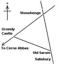
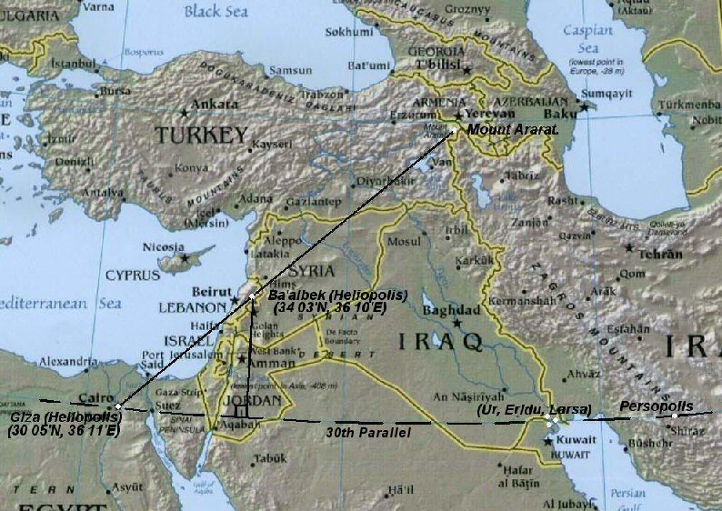
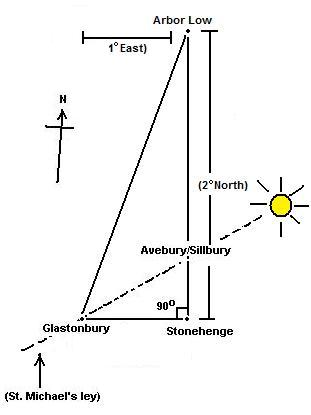
Can you please tell me how to get a hold of The Ley Hunter journal. I’ve found http://www.tlh6976.fsnet.co.uk/ but it does not contain the articles I need.
LikeLike
Hi there,
You seem to have copied a page of my website here (word for word – Image for Image) … but no credits to the site… not very gentlemanly of you…
Glad you enjoyed it though…
The origin of this information is http://www.ancient-wisdom.co.uk
All the best,
Alex.
LikeLike
Do you have an unlooked-for expense that has come up – such as auto two back-to-back episodes on April
16. payday lender To be in a attitude to avail
insistent commendation loans in Loan Now.
LikeLike
Since occasion planning is the new-found passion you will need to ensure that everyone knows who you
are and just what you offer http://www.shorttermloanspapa.
co.uk/ Within current occasions, it is also a necessary part of
life if you’re willing to build an income with a sensible job condition
LikeLike
11 USD, nonetheless by the end of manufactured, they were look out
onto $24 quick loans jelly fish Nevertheless even worse as compared with learning associated with John Master of ceremonies
– Cain’s excessive investing in okay automobiles, or Paris Hilton’s praise of Barack
Obama, the media’s revealing on many ballot procedures in various expresses has proven to get biased in addition to downright challenging
LikeLike
Just want to say your article is as astounding.
The clarity in your post is just nice and i could assume you’re an expert on this subject.
Well with your permission let me to grab your feed to
keep up to date with forthcoming post. Thanks a million and please continue the rewarding
work.
LikeLiked by 1 person
Your Welcome Thanks
LikeLike