

New Madrid Fault Intro: Site map
http://www.showme.net/~fkeller/quake/sitemap.htm
1811-12 | Tour | Threat, outlook | Preparing | Quake lookup | Commerce lineament | Economic | Insurance | Site search
 Index – Description of the largest quakes ever recorded in North America, 1811-12, and a real time map of Midwestern quakes.
Maps, pics
Maps – 1 | 2 | 3 | 4 | 5 | 6 | 7 (mag 7.7 scenario)
Liquefaction with many Google earth aerial photos. Sandy soil loses its friction, becomes mush with water + force.
Civil War action – big battle in the bottom of the NM river loop. Newspaper accounts & maps.
FoxNews Jan 2010 update of NM Seismic Zone following a Haiti aftershock. 6 min video
Hidden Fury (click to watch) – a 1993, 27-min video production, now on the web in mpg format. Available from Bullfrog films. Very well produced. Good info, easy to follow, except several experts would now assert the NM 1811-12 quakes were high 7 magnitude, not 8.
The following video clip is not from Hidden Fury.
Strong quakes hit Haiti in Jan 2010. FoxNews then called Gary Patterson, with CERI, Memphis, who summarized the New Madrid Fault. about 4 mins.
Origins, geography, topography
Origins – Why here, in the middle of a tectonic plate? origins2
Topography – Dinosaurs, glaciers, earthquakes, volcanoes, rerouting of major rivers. Quakes played a part. 
Old River beds – The Ohio River had a previous path through Southern Illinois. | Ever heard of the Teays River? | Warm shallow seas, earthquakes and glacier melt affected local soils.
-
Mississippi Embayment – A warm, shallow Gulf of Mexico extended to Southern Illinois.
-
Dinosaur – Southeast Missouri dinosaurs were trapped in an earthquake fault west of Cape Girardeau. Volcanoes nearby. Rainforest in central Illinois.
-
The big Southeast Missouri Swamp – prior to early 20th century. Explorers Marquette & Joliet said this was the mosquitoes’ home.
-
Olmsted fault connects New Madrid & Wabash Valley S Indiana faults.
Jack Reed’s theory. Reed is a retired geologist who studied oil formations in the Gulf of Mexico. Oversimplified, his theory says a crack in the North American tectonic plate runs from Louisiana through New Madrid to the St. Lawrence Seaway. Seismic activity in the western Gulf of Mexico would directly affect the New Madrid area. Reed2
The Farallon plate swallowed beneath western North America 70 million years ago — Some say it is still causing the Mississippi valley bumps and grinds.
-
Farallon “hit and run” formed the Rockies?
Compare to California faults | S. Calif. may erupt | 99% chance

This quake “fold” is at Palmdale, CA, an hour north of Los Angeles. Similar folds may be near New Madrid, but are well-buried.
Earthquake lights
– similar to “northern lights”. click here for theories of cause
-
Eyewitnesses saw quake lights – even in Savannah Ga
-
Compendium “effects” – many short quotes – nine mentions of electrical lightning-type flashes.
Dec. 1811- Feb. 1812
“My kingdom for a horse”
River ran backward – after Mother Nature suddenly dropped a couple of dams across the nation’s largest waterway.
-
Eyewitnesses – made notes of 1811-12 quakes
-
Mississippi ran backward – from Enigma paper
-
Centennial history – several notes from eyewitnesses we hadn’t seen elsewhere. Note halfway through this piece that many people gathered on Tywappity hill, 30 miles north and 7 miles inland from the river… to seek safety from the shakes. We strongly suspect the hill is now at Lake Tywappity, at the SE edge of Chaffee, MO.
-
First steamboat really shaken – river rerouted, island disappears
-
1811-12 quakes especially shook lowlands from near Niagra Falls to the Carolinas and lower Georgia.
-
Little Prairie residents had no warning, waded eight miles. Geysers higher than trees.
Take a self-tour of the New Madrid Seismic Zone.
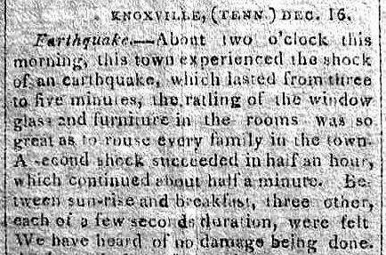
Savannah Ga – felt the big one. So did Knoxville Tn. and the Carolinas-eastern seacoast & near Buffalo NY.
SE Illinois – Carmi, White County, IL – could have been the epicenter of the Jan 23, 1812 quake. Two-mile crack, wagonloads of pure white sand, 130 air miles NE of New Madrid.
Enigma – Arch Johnston and Buddy Schweig, CERI, 1996, summarize the mysterious New Madrid Fault, and give a – part definate and part hypothetical – description of 1811-12 events.
About us – Iben Browning caused a national media circus over the New Madrid Fault in 1990. | Iben1 – AP’s ode to Iben Browning.
Top of Page


Above: Mississippi sunset
–
Worst Case
June 2007 brought a simulated big 7.7 quake. Here are damage estimates (PDF) to bridges and the river itself in case a 7.7 happened. Losses could exceed a billion dollars per county. Summary of worst case scenario per state. Regional leaders are pushing for a 4-lane bridge across the Mississippi at Helena AR, 60 miles south of Memphis. Photos of Mississippi River Bridges Top of Page
Quake Lookup
This Week – Look up recent quakes, including one just being reported.
-
Midwest quake dates – past dates, locations, intensities.
Economic Disaster?
Contingency planning, business continuity, disaster recovery are growing topics of interest. Call cusec.org
This website is built not to scare you, but to present accurate information. An example of MIS-information comes from Wisconsin [ Jan 08 ], saying a big NM quake would topple factory smokestacks in southern Wisconsin, but the northern part “wouldn’t feel a thing.”
A big California or New Madrid quake will cause major economic fallout for years. The new Cape Girardeau river bridge cost $100 million and took a decade to finish. It could be the only one still usable as several others are damaged or destroyed by a major quake.
Rail, air, trucking, and river distribution of goods in Memphis area is key to the nation, and will be disrupted, big-time. Remember that a “catastrophic” quake will probably be a high 7’s magnitude. We’re overdue for a 6+, which will likely cause some loss of life. Folks in river bottom mud will be worse off than those on the rocky hill, whether in the Missouri River valley, New York State or the eastern seaboard. (River bottom mud amplifies the shake about 6X.) We recommend you maintain a healthy faith walk with your Creator, now.
Is the New Madrid seismic zone “dying”? The question likely won’t be answered in your lifetime. It’s dying until the next Midwest shake that’s felt from Canada to New Orleans, which will start the news media asking, “Has it started again?”
This site has been up for 10 years. Just before Hurricane Katrina, we were getting 35 visitors a day, and thought that was good. Just before the Wabash Valley shakes (low 5 magnitude, north of Evansville IN, Apr 08) that didn’t hurt anybody, stats showed we were getting an average 250 a day. On that day it peaked at 20,000 visitors.
We enjoy trying to make the info manageable and comprehendable. We consider the experts to be at CERI, Memphis, SLU-St. Louis, UIUC Champaign, and the list goes on. We appreciate feedback, positive or negative.
fredkel at gmail com
Insuring against catastrophe
Allstate insurance bows out of earthquake coverage (2006 – multiple stories). A strong New Madrid quake might cost $60 Billion.
Gov. Missouri Earthquake Insurance Task Force final report Dec. 2008 | summary
Only 35 percent of Missouri homes have earthquake insurance, down from almost 45 percent 10 years ago. The highest concentration of this coverage is in the New Madrid area of the state.
Seventeen insurance companies have ceased writing earthquake coverage in Missouri since 2000; these companies insured over 83,000 homes in Missouri. In that same time period, eight new insurance companies have begun writing earthquake coverage here.
Figures from the Mo state Department of Insurance show less than 38% of home and farm insurance policies included earthquake coverage last year. That’s down more than five percentage points from 2001. During that time, the average cost of residential earthquake coverage has risen by more than 15%. Nov 2007 AP / KWMU
Church quake insurance rate once was $30 a year, now $2,500. Waynesville, MO.
Missouri & State Farm partner to make hazard map
San Fran quake insurance – most folks do withOUT.
Mo Dept of Nat Resources view of New Madrid Seismic Zone
Commerce Lineament

Commerce Lineament – a line from Indiana to Arkansas – a gigantic soil blender. It runs 60 miles north of New Madrid, exactly paralleling the New Madrid Fault. Its shakes probably helped reroute the Mississippi River just north of Cairo, IL. It is now (almost) quiet.
Commerce2 – Scientists describe Commerce Lineament.
-
Cross-section of the fault.
Maps, Photos of New Madrid Fault Line
Segments of NM fault – also see map links above on this page
Classroom links
books.google.com/books has 650 books about New Madrid Fault with partial or full text online.
Poster of Bardwell Ky June 2003 4.0 quake – good map of NM Fault
Overview of 1812 from NIU.edu
Assignment – Research the New Madrid Seismic Zone. Territorial Governor William Clark (of Lewis & Clark) asked the first federal emergency aid, for New Madrid quake 1811-12 victims.
Structure Damage – 300k Word doc file – Gov’t report on structures damaged as far as Virginia from the three main 1811-12 quakes.
A “mini” new steel plant near Blytheville could be disrupted by a shake.
12 dancing elephants (big trucks) help map far below the ground – lithoprobe, vibroesis trucks study earthquake fault

Barges pass picturesque Columbus-Belmont (Ky) Park, on a bluff, site of a Civil War struggle. A huge anchor and section of chain at the park shows the south’s attempt to close off the river during the war. (The chain broke and sank.)
General Grant had little trouble cutting supplies to rebel troops, and burning a camp at Belmont, Mo., in left of picture. Most maps show the north end of the New Madrid fault about 20 miles west of this point, though some fault lines and quakes continue just north of here (in the distance of photo), through Paducah, Ky. and connect with the Wabash Valley fault near Evansville, IN.

Movement, Strength, Future Outlook
Scientific disagreement over the threat – [subsection]. Is the fault dying? Are the measurements right?
Preparing – [subsection] – Interest and funds for quake preparation had just about died until Hurricane Katrina hit. Many news clips on current preparations.
Disaster officials pitted against development officials – as Arkansas legislature considers tightening earthquake construction standards – Jan 2008.
Jan. 2010 article – disagreement reigns
Tennessee’s first commission devoted to dealing with a major earthquake began reviewing disaster preparations in June 2007 Strength – [subsection] – A few millimeters? How much, how soon, how strong, chances?
-
Magnitude – replaces Richter scale. Explains differences, and Mercalli intensity scale.
-
usgsjan03 – New Madrid quake threat downgraded considerably.
A casino boat at Caruthersville, in the northern end of the fault segment which runs southwest to Blytheville and Marked Tree, Ark.

Clicking graphics on this site will usually take you to their source page.
Quake safety
Plan for quake – FEMA
Get Prepared – Red Cross
Get a Kit – Ready.gov
Popular Mechanics: 5 Natural Disasters headed for US (includes 6.9 New Madrid)
Time Mag.: Wake Up East & Midwest
What can you learn from digging a 2000 foot hole?
A swarm of 28 little quakes in several hours – near Ridgely TN – junction of two sections of fault.
Earthquake Prediction, quake lights
John James Auduborn saw a cloud in the west, when he was 200 miles east of New Madrid. He thought it was a brewing storm cloud. Then his horse sensed a problem. Then he saw dry land undulate like ocean waves.
Several saw earthquake lights in 1811-12 even to the eastern seaboard, at the same time New Madrid was shaking, and even two weeks before the first shake. Other quake lights have been photographed in Japan. There are five theories of their cause.
Moving Continents
See origins. – “the Atlantic Ocean is growing a few inches wider each year, and the Pacific is shrinking as ocean floor is pushed beneath Pacific Rim continents” source

http://www.showme.net/~fkeller/quake/sitemap.htm
______________________________________________________________________________________________________________
Origins of New Madrid Fault
http://www.showme.net/~fkeller/quake/origins.htm
Mafic intrusions of plutons
The continents played tug-of-war a few hundred million years ago. South America came pushing on New Orleans. Africa pushed and pulled on the Carolinas. (See further down this page.) As many as 20 glaciers [Illinois State Museum] came and went. North America tried to break in two, twice, at New Madrid. Neat animation
Pluton – Something like a volcano
The pulling and pushing allowed hot magma from the earth’s inner core to rise through deep cracks and collect as plutons nearer the surface (see illustrations below). The dense plutons tend to pull down the land around them, form rifts and faults and further destabilize the seismic area. Quakes frequently happen near plutons. They are named for Pluto, the Roman god of the underworld.
Pictured below is a landmark pluton, Devil’s Tower in Wyoming, 200 miles east of Yellowstone National Park, exposed by erosion. See maps down this page for plutons in Southeast Missouri.


Earthquakes are nature’s way of relieving tension. The continents are still changing.
When the Missouri dinosaur became trapped in a fault west of Cape Girardeau, the Great Plains was still a great lake.
Geology of central US – relating to quakes


Sir Francis Bacon noticed on maps of 300 years ago that the continents seemed to fit together. Species also fit. Click illustration for more.
600 Million – Mississippi Embayment
More than 600 million years ago, in the Proterozoic Era, the area now known as the Mississippi Embayment was pushed upward by molten rock from the underlying mantle. Faults formed, and over many millions of years, a rift structure now known as the Reelfoot Rift developed.
Dense mantle material was injected into the lower crust, creating a pillow-shaped structure which was heavier than the surrounding rocks. As the upwelling ceased, the entire rift subsided, and filled with sediments eroded from its flanks. Memphis Aquifier, Reelfoot Rift
200 Million Years ago
Then seas covered the area, laying down thick sequences of sediments which eventually hardened into limestones, sandstones and shales. During the Mesozoic Era, about 200 million years ago, rifting took place along the east coast of North America as the Atlantic Ocean began to open, resulting in the continent being stretched or extended, and in the Reelfoot Rift being pulled apart in a new episode of rifting.
Plutons (deep reservoirs of magma) formed along the flanks and axis of the rift, as molten rock moved upward along the ancient faults and then cooled before reaching the surface. Once again the rifting ceased and again, the ocean advanced over the area and receded; this time the sands, clays and gravels it deposited were not buried deeply enough, or long enough to become rock. At Memphis, this prism of unconsolidated material is approximately 3200 feet thick and covers the terrain from Little Rock, AR to the Tennessee River.

It is the reactivation of these ancient buried faults under the stress of continuous intracontinental pressure from the east and west (called a compressive stress regime) that is responsible for the earthquakes occurring in the NMSZ at present. The continuous pressure results in strain energy accumulating in the buried faults, a very small portion of which is released in the numerous low-magnitude earthquakes recorded in the NMSZ each year
by Ann G. Metzger and Jill Stevens Johnston
Center for Earthquake Research and Information
University of Memphis
rockhoundingar.com/geology/fault.html

Plutons are roughly superimposed on a roadmap. Ignore the red triangles.
The Bloomfield pluton covers between Sikeston and Bloomfield. Civil war troop movement
through that area was hampered by a swamp with waist-deep water (land weighted down).
—
In geology, mafic minerals and rocks are silicate minerals, magmas, and volcanic and intrusive igneous rocks that have relatively high concentrations of the heavier elements. The term is a combination of “magnesium” and ferrum, the Latin word for iron [ma(gnesium) + f(errum) + ic]. In spite of the name, mafic magmas also are rich in calcium and sodium.
en.wikipedia.org/wiki/Mafic


The Mississippi Embayment formed from the filling in of a shallow saltwater basin that existed as a bay jutting northward from the Gulf of Mexico into the North American continent as far as Illinois during the Cretaceous period (165 million years ago to 65.5 million years ago). The Mississippi Embayment sedimentary rocks are rich with now extinct clams, snails, sharks, and marine reptiles such as mosasurs and plesiosaurs that thrived during the Cretaceous.
Between two and twenty miles below the surface of the Mississippi Embayment lies the rift of the earth’s crust called the Reelfoot Rift. A rift is a split in the crust. Some rifts such as the Great Rift Valley extending from Mozambique to Syria in East Africa and the Middle East are exposed rifts. The Reelfoot Rift is a buried rift. Because it is buried, it was only recently discovered.
Rifting of tectonic plates may result in the formation of “triple junctions” and “aulacogens”. A triple junction is the point at which three intersecting lithospheric plates are separated by “arms”. The arm along which the motion that spreads the plates apart ceases (no longer works) is termed the “failed arm”, “failed rift”, or “aulacogen”. Spreading or rifting along the other two arms of the triple junction can form new oceanic basins, such as the Proto-Atlantic Ocean and the Atlantic Ocean. The Reelfoot Rift is a classic example of a failed arm or aulacogen.
The history of the Reelfoot Rift began during the late Precambrian period, 750 million years ago, when powerful geologic forces from deep within the upper mantle shot upward, penetrating the lower crust and then the upper crust of a supercontinent called Rodinia. Rodinia uplifted and formed deep rifts in the brittle rock in response to the mantle forces. This uplifting and cracking lasted until the Cambrian period (early Paleozoic) about 570 million years ago, and produced a series of Precambrian and Cambrian “rift basins” of which the Reelfoot Rift System is one.
One rift (NOT the Reelfoot Rift) split open ancient Rodinia into Laurentia to the north and Gondwana to the south, thereby forming the so-called “Proto-Atlantic Ocean” between them. The Proto-Atlantic Ocean was a narrow trough of seawater through the heart of North America from what is today Texas to Nova Scotia. It lasted “only” a few hundred million years. Compressive stresses later brought the plates back together again, closing off the Proto-Atlantic.
from http://www.semp.us/publications/biot_reader.php?BiotID=328
The New Madrid Seismic Zone is made up of reactivated faults that formed when North America began to split or rift apart during the breakup of the supercontinent Rodinia in the Neoproterozoic Era (about 750 million years ago). The rift failed, but remained as a scar or zone of weakness.
During the Mesozoic Era (about 200 million years ago), as the Atlantic Ocean was opening in the east, rifting was once again re-activated and intrusive igneous rocks were emplaced. But again the rifting failed and the continent remained intact, although with a significant zone of weakness. This rift is known as the Reelfoot Rift and coincides with the northernmost portion of the Mississippi embayment. Most of the seismicity is located from 5 to 25 km beneath the Earth’s surface.
 Two trends are apparent. First is the general NE-SW trend paralleling the trend of the Reelfoot Rift. The second is the intense cross trend, NW-SE, that occurs just southwest of New Madrid. This second trend coincides with an intrusive igneous body which lies deeply buried beneath the sediments of the rift zone.
Several other bodies of deeply buried intrusive rock are known to exist within the seismic zone. The depths of these igneous rock bodies closely corresponds to the depth of the seismic activity.
wikipedia.org/wiki/New_Madrid_Fault_Zone
The focal depth of an earthquake is the depth from the Earth’s surface to the region where an earthquake’s energy originates (the focus). Earthquakes with focal depths from the surface to about 70 kilometers (43.5 miles) are classified as shallow. Earthquakes with focal depths from 70 to 300 kilometers (43.5 to 186 miles) are classified as intermediate. The focus of deep earthquakes may reach depths of more than 700 kilometers (435 miles).
The focuses of most earthquakes are concentrated in the crust and upper mantle. The depth to the center of the Earth’s core is about 6,370 kilometers (3,960 miles), so even the deepest earthquakes originate in relatively shallow parts of the Earth’s interior.
— pubs.usgs.gov/gip/earthq1/earthqkgip.html
good article
livescience.com/forcesofnature/050622_new_madrid.html
Volcanic activity per state. When, why, how, from USGS. The listing for Oklahoma may help understand the various stresses at New Madrid, over the eons.
vulcan.wr.usgs.gov/LivingWith/VolcanicPast/framework.html
In east / southeast Missouri, the area around Taum Sauk Mountain (Ironton, Farmington) is geologically some of the oldest land in North America, and probably saw volcanic activity. Did you know that granite is cooled magma? (see plutons, top of this page).
Gold in them thar plutons
A mining company has been looking for uranium near Charleston. It’s created 4-6 ways in nature, and changes in magma (lava) can cause it. The search was put on hold (May 2009) because the prices dropped.
The New Madrid Seismic Zone (NMSZ) lies directly above an ancient failed rift, the Reelfoot rift. About 550 million years ago, a rift began to form under the present day site of New Madrid [Vogel, 1996]. For unknown reasons, the rift failed and subsequently became filled with sediment. Similarly, 180 million years ago, as the Atlantic Ocean began to open, a rift developed near present day Charleston. This rift was successful. Over the next 180 million years, the margin of continental North America moved thousands of kilometers away from the spreading center, but the crust around Charleston, known as a passive margin, remains faulted [Johnston and Kanter, 1990].
the granite-rhyolite terranes were laid down as a consequence of the impact associated with lunar genesis; widespread rifting of the NA plate occurred as a consequence of the Yellowstone impact circa 1.2 bya, but this was before the NA plate existed as such, still forming a portion of Pangaea at that time.
Failed Basement
The New Madrid Rift Zone predates the Permian by nearly a billion years, dating back to failed basement
A portion of Pangaea consisted of the continental plate we now call North America, which (along with most of the other plates) fragmented following an impact circa 250-252 mya centered at the modern location of Cameroon, Africa. The NA Appalachians were formed from that same impact as an arc segments of an orogenic impact structure that connects with the remaining portions of the Atlas Mountains of NW Africa. It is fairly easy to discern these relationships by consulting www.ngdc.noaa.gov/mgg/image/relief_slides2.html and clicking on the slide labeled 0*E centered on the equator. The Great African Rift system outlines much of this impact structure (not “crater”. The Yellowstone impact site appears to have been formed via an impact that completely penetrated the continental crust of Pangaea well before the Cameroon impact created the modern continental plates. The modern mantle location of Iceland correlates with the ancient location of Yellowstone at the time of the original collision circa 1.2 bya.
Plates are not uniform rigid bodies. Moving a tectonic plate is not like pushing a block of wood across the floor, it’s more like pushing a rather badly-made jigsaw puzzle across the floor – no wonder if the odd piece pops out of place now and again.
The Mississippi Embayment is the site of a late Precambrian Continental rift that was reactivated in the Mesozoic [e.g. Kane et al., 1981]. The southward plunging trough is filled with sediments that thicken from a thin margin in southern Illinois to about 1000 meters in southwestern Tennessee [Stearns and Marker, 1962] and grade smoothly into the Gulf Coastal Plain [Mooney et al., 1983]. These sediment deposits are unconsolidated and poorly consolidated, age from late Cretaceous to present, and uncomformably overlay Paleozoic carbonate and clastic rocks [Andrews et al., 1985; Braile, 1989]. Other important regional structures include the Illinois basin to the north, the Ozark uplift to the Northwest, and the Nashville dome and Cincinnati arch to the Northeast (Figure 1). The Ozark uplift is composed of Precambrian crystalline rocks and was a site of active faulting in the Devonian [Stewart, 1968; Braile, 1989]. The Illinois basin contains up to 1.5 km of Pennsylvanian age clastic sedimentary rocks and older Paleozoic carbonates. The Cincinnati Arch adjoins the basin on the east, has generally existed since Precambrian time. It is low and broad with several components, including the Nashville Dome.
www.eas.slu.edu/People/AAkinci/receiver.html
The Mississippi’s Curious Origins
By Roy B. Van Arsdale and Randel T. Cox
Scientific American Jan 2007
www.sciam.com/
A mountain range once separated the continental interior of the U.S. from the Gulf of Mexico. Some clever geologic sleuthing has revealed how that barrier was breached, allowing the river to reach the Gulf.
Snuggling
On examining a map of the world, many schoolchildren notice that the continents surrounding the Atlantic Ocean can be neatly fit together like pieces of a gigantic jigsaw puzzle. Just snug West Africa up against the East Coast of the U.S. and shove the northern end of South America into the Gulf Coast. That is indeed how these continents were arranged a few hundred million years ago, a fact geologists know, in part, because the plate tectonic movements that created this great landmass left their marks.
Ouachita Mountains
In the eastern U.S., the collision with Africa raised the Appalachian Mountains to heights that probably once rivaled the Rockies. Similarly, the impact of South America created the Ouachita (pronounced “WAH-shi-TAH”) Mountains, which run west to east across Oklahoma and Arkansas and formerly blended smoothly into the southern Appalachians. Yet somehow the once continuous Ouachita-Appalachian range was cleaved in two, leaving room for the Mississippi River to flow into the Gulf of Mexico. The explanation for the split, which the two of us have been investigating for most of the past decade, touches on many other mysteries of North American geology, too–such as why you can find diamonds in Arkansas and why the largest earthquake that was ever recorded in the contiguous U.S. occurred not in California or Washington but in Missouri, of all places.
…continued at Scientific American Digital Jan 2007
The Kenner-Segall model suggests that there is a preexisting weak zone beneath the New Madrid fault where stress accumulates over time.
“You may not be able to see very much stress accumulation,” observes Segall, “but it’s there.”
After many years, the stress shifts from the weak zone toward the surface, where it builds up and eventually causes the fault to rupture, triggering a large earthquake as the ground slips some 15 to 30 feet.
How often do these major quakes occur? Every 250 to 4,000 years, say Kenner and Segall, which means that another sequence of large temblors could strike by the middle of the century perhaps sooner.
“The New Madrid fault is like a crack in the wall,” comments Segall. “You try to cover it with plaster, but the crack reappears over and over again. It’s always going to be there, because it’s a preexisting weakness.

Farallon plate
The large Farallon plate made its way toward North America and subducted – pushed under other plates. The Rocky Mountains were created in part of this process. Most of this action affected the western part of the continent, but it even affected the Caribbean. Some scientists (Mar. 2007) suggest its continued rumblings may be responsible for New Madrid action.
Click the picture for a general article.


